Showing posts with label desert. Show all posts

Friday, October 17, 2025

Desert People Without Water

I recently visited the ruins at Honanki and Palatki.  These are prehistoric settlements built into the red rock cliffs near Sedona, AZ.  Today, the people who built these dwellings are called "Sinagua", which comes from Spanish for "without water".  But everyone needs water, right?  I wondered where these people got drinking water.

I looked for springs around Honanki and Palatki and didn't find any.  That's weird!

Zoom in to see locations of Honanki (H) and Palatki (P) in relation to USGS-mapped springs (blue) and NAU-mapped springs (green).

Although springs have dried up in recent times, the USGS spring data was mapped in the late 1800s / early 1900s when many more springs were flowing.  It looks like the geology of the Sedona Red Rock cliffs just don't produce springs.  So even if the location of springs was different 800 years ago, it would be surprising if there were springs in the cliffs where these people lived.

The closest mapped spring (blue dot = unconfirmed water source) is 1.5 and 2.7 miles away, respectively, but there is no evidence of water in the aerial imagery.  The next closest (green dot = confirmed water source) is 4.7 and 3 miles away, respectively.   Neither Palatki nor Honanki is even built in one of the larger drainages that might flow more often/longer; the drainages that feed their valleys are quite short.  

I don't think these settlements had access to aboveground water throughout the year unless they dug wells or used cisterns to store water.

These and other prehistoric communities in the desert Southwest often built cliff dwellings high above canyon floors, far from surface water sources.  Archaeologists believe these people collected runoff during rainstorms using check dams and seeps, and stored water in cisterns or ceramic containers for later use.

Across the prehistoric Southwest, populations used ingenious methods to exploit scarce water:

  • Rock overhangs and cisterns captured and stored rainwater.
  • Seasonal mobility allowed families to occupy dry sites part of the year.
  • Terraced fields, check dams, and soil-retention walls conserved moisture for crops.
  • Small permanent settlements clustered near ephemeral water sources, such as seeps and seasonal pools.

In conclusion, while many large settlements in the prehistoric Southwest were built near springs or rivers, groups like the Anasazi, Sinagua, and others developed highly effective ways to survive in water-scarce environments through dry-land agriculture, runoff collection, and strategic mobility.

Friday, May 24, 2024

Joshua Trees Flower Episodically in Arizona

Intro

Joshua trees are large, visually-striking trees in the Mojave desert.  Most of them are in California and Nevada, but there is also a population in the western part of Arizona.  They are frequently photographed and there are more than 17,000 observations (1,000 in AZ) saved on iNaturalist, a website and app used to document biodiversity.  

Arizona Joshua Tree locations observed on iNaturalistiNaturalist.

Joshua trees produce showy clusters of white flowers at the tips of their branches in March, but this year I noticed they were not flowering.  I wondered how often they produce flowers and decided to answer this question using data from iNat.

53 observations in Arizona showed evidence of flowering, always in March and April.  

Methods

iNat observations of Joshua Trees (Yucca brevifolia) in Arizona were marked using the Plant Phenology option in the Annotation Field.  Plant phenology (flower budding, flowering, or fruiting) was determined based on visual inspection of the saved photos in iNat.

The iNat website has a nice phenology visualization tool.  This view is filtered to show only Arizona observations.  However, it cannot show differences in phenology from one year to the next.  

Observations were then filtered on the iNat Explore page by adding &term_id=12&term_value_id=13 to the URL and downloaded for analysis in Excel.

More info about using iNat search URLs.


Results

I graphed the results starting in 2017, because there are fewer iNat observations before 2017.  It appears Joshua Trees flower episodically.  According to this data, Joshua Trees flowered in four out of the last 7 years.  They appear to alternate years from 2017-2020, but then skipped 2021 and flowered in both 2022 and 2023.  


It is interesting to note that the Arizona Joshua Trees didn't flower in 2020, which was one of the wettest springs in the last 10 years. I wonder whether the spring moisture determines flowering, or if perhaps other climate variables, such as moisture in the fall, are more important.  Another possibility could be that the trees are only able to flower every other year, and that the trees were inhibited from flowering in 2020 because of the large number that flowered in 2019.  

According to this data they were able to flower in both 2022 and 2023, but at reduced numbers both years.  Perhaps the plants flowering in 2023 were different from the trees that had already flowered in 2022?  I can't answer that question with this iNat data.  While it appears that the areas of flowering in 2022 and 2023 were the same, not all of the Joshua trees in a given area necessarily flower, even in good years...

Monday, October 31, 2022

Fire Retardant Visible From Space

The Bush Fire started on the West side of Highway 87 in Arizona on June 13, 2020.  Drive by strong winds from the SW, it soon spread to the highway median and then crossed to the East side of the highway.  From there, it went on to burn 193,000 acres until it was completely contained on July 6, 2020.
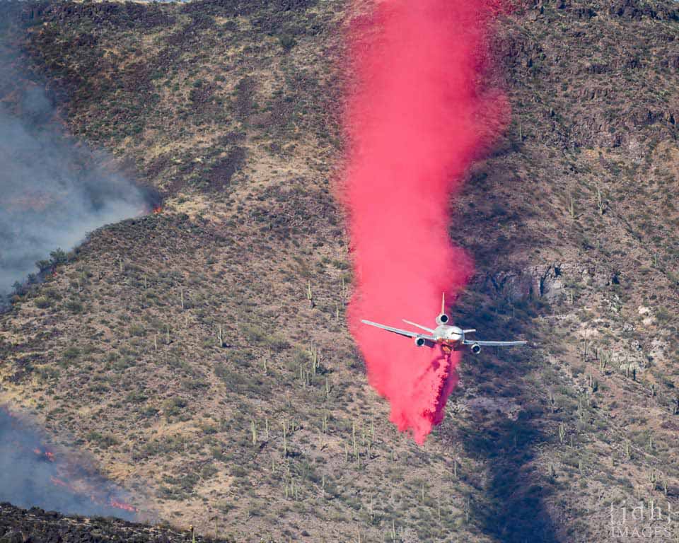
Air tanker drops retardant ahead of fire.  Photo by JDH images.  https://wildfiretoday.com/tag/bush-fire-in-arizona/

Air tankers were extensively used in the initial attack on the fire, and Google Earth images of the fire start location show some interesting features.  These images were taken on June 20, 2020, 7 days after the fire had burned this location.

The fire started on the West side of 87.  Fire retardant strips are visible in several locations.

Where the fire was backing against the SW wind, retardant drops were successful in stopping the spread of the fire.  A small bulge near the top of the image shows where fire crossed the line, but was contained.

Retardant drops on the south side of the fire were not successful in stopping the fire, but may have been instrumental in slowing the fire which allowed it to be stopped at the dirt road.

Retardant drops directly in front of the wind-driven fire were not successful in holding against the onrushing flames.  The fire spread over and around the retardant line in this image.

At another location on the same date, the fire can still be seen actively burning.


Monday, May 31, 2021

Restoration in hyper-arid environments?

 Is is possible to plant trees and restore grassland savanna in a hyper-arid desert?  

In Al Baydha it sometimes doesn't rain for 26 months, and apparently there are trees that can survive and thrive in that environment.

The Story of Al Baydha: A Regenerative Agriculture in the Saudi Desert.


Wednesday, January 06, 2016

Welcome to the High Desert of New Mexico, USA


Surviving in the High Desert of New Mexico is like visiting another planet.

I suggest you find a house with a good airlock and sunshade, but you won't be able to filter out the cosmic rays; living up here is like being an airline stewardess.

The desert has a way of simplifying human needs: water, oxygen, respect (for the sun), oh, and more water.

The most important thing is water. You have to drink all the time. When you wake up in the morning you must drink a full nalgene; you've lost at least that much through exhalation during the night. I suggest miso bone broth soup to replace the electrolytes as well. Its dry here and you can't always tell when you're sweating because evaporation is so efficient.

Sometimes you can't drink enough water. The answer is coconut water. Always keep some at hand in case of emergencies.

High altitude. One of the commonest complaints (after dehydration, always check that first) is low oxygen. People forget to breathe. You have to really move that diaphragm! Ginseng and other tonifying herbs might help, too. Oh, and bone broth soup. Think like a sherpa.

Sun. I used to go without sunblock, but we're too close to the sun here. Respect the sun. Always wear sunblock when you have exposed skin - or wear a burkha. UV-blocking sunglasses are also, sadly, necessary. I hate wearing glasses, but if you don't the Light will wash away your world. Yes, it is possible to sunburn the back of your eyes.  8-(

Moisturizer. Dry skin is serious. One secret to prevent over-drying is to always end showers with cold water; it tones the muscles and closes pores in the skin so you don't lose all your hard-earned moisture. Never, ever use drying soap. I don't think that should be a problem, but I'm warning you now: Don't let cracks form on your hands or it will be Too Late, and you'll be covered in bandages like a mummy.

 Welcome to New Mexico!

Tuesday, April 21, 2015

The Theory and the Reality of Shelterbelt Afforestation Projects

The Theory of Shelterbelts

The Reality


Introduction:  dust bowl, us efforts

Following the dust bowl years in the U.S. the government planted 220 million trees in a strip 100 miles wide, stretching 18,600 miles from Canada to the Brazos river.  1935-1942  Today, the growth and vigor of many trees has declined due to close spacing, age, and invasion of undesirable short-lived trees.  Wikipedia.


There are currently two major afforestation programs, one in China, and one in the Sahel.

Great Green Wall in China. 

This project aims to afforest 90 million hectares and eventually contain 100 billion trees in a 4500km belt.

A recent paper by Tan (2014) found decreased dust transport due to the plantings so far.  But independent Chinese media reported in 2013 that dust storms were increasing:  For centuries in northern China, annual sandstorms, called the Yellow Dragon, have been ripping through the city.  Wind erosion is obvious and most pronounced in spring, when sandstorms are common and the vegetation is still absent or dormant after severe winter temperatures. Sandstorms have increased in the last few years, calling into question whether the Great Green Wall is working.


Liu Tuo, head of the desertification control office in the state forestry administration, is of the opinion that there are huge gaps in the country's efforts to reclaim the land that has become desert. At present there are around 1.73 million sq kilometers that have become desert in China, of which 530,000 km2 are treatable. But at the present rate of treating 1,717 km2 per year, it would take 300 years to reclaim the land that has become desert.  


Background
In early times, Korqin was not a semi-desert, but savannah-type woodland, in transition between dense forest and the steppe zone. The rolling sand-sheet was deposited during the last glacial period (12000 years BP). During 10,000 years of vegetation growth, thick dark topsoil developed. Since historical times, the region has gone through several cycles of man-induced desertification and subsequent recovery, when human pressure lessened. Fertile dark topsoil vanished and extensive dune fields gradually build up.  Overgrazing (by cattle, goats, sheep, camels, horses), clearing of land for agriculture and over-cutting of trees and shrubs in this vulnerable ecosystem have resulted in an increasingly severe land degradation and desertification.

Other Approaches?
There are many who do not believe the Green Wall is an appropriate solution to China’s desertification problems. Gao Yuchuan, the Forest Bureau head of Jingbian County, Shanxi, stated that “planting for 10 years is not as good as enclosure for one year,” referring to the alternative non-invasive restoration technique that fences off (encloses) a degraded area for two years to allow the land to restore itself.  Soil fertility, already critically low, has shown a sharp decline as all organic residues from crops are removed for fuel and fodder during wintertime. Willow and poplar stands are pollarded in autumn, before leaf fall, for the same purpose. The continuous removal of potential nutrients to the soil is not balanced by the relatively small amounts of manure and inorganic fertiliser applied to crops.

Problems
 Jiang Gaoming, an ecologist from the Chinese Academy of Sciences and proponent of enclosure, says that “planting trees in arid and semi-arid land violates [ecological] principles”.The worry is that the fragile land cannot support such massive, forced growth. Tree growth in Korqin is largely dependent on the presence of a high groundwater table, fed by percolation and inflow from the western and southern mountainous areas. The long-term trend of a decreasing depth of the groundwater table is due to an increasing demand for water to irrigate crops and for human and industrial needs. If the trees succeed in taking root, they could soak up large amounts of groundwater, which would be extremely problematic for arid regions like northern China.  For example, in Minqin, an area in north-western China, studies showed that groundwater levels have dropped by 12–19 metres since the advent of the project.

Progress So Far
As of 2009 China’s planted forest covered more than 500,000 square kilometers (increasing tree cover from 12% to 18%) – the largest artificial forest in the world.However, of the 53,000 hectares planted that year, a quarter died. In 2008 winter storms destroyed 10% of the new forest stock, causing the World Bank to advise China to focus more on quality rather than quantity in its stock species.  FAO report

But the program’s widespread tree planting campaigns typically allot only one or two species of tree to an area. Professor Jiang wrote in a 2009 Epoch Times article, “In Ningxia, for example, 70 percent of the trees planted were poplar and willow. In 2000, one billion poplar trees were lost to a disease (Anoplophora), wiping out 20 years of planting efforts.”  FAO report followup

More criticisms:  Wikipedia.


Great Green Wall in Africa - the Sahel

The Great Green Wall initiative is much more nuanced than simply planting a belt of trees across the continent: “Behind the name or the brand ‘Great Green Wall,’ different people see different things. Some people saw just a stripe of trees from east to west, but that has never been our vision,” he says. “In Niger, Mali, and Burkina Faso . . . natural regeneration managed by farmers has yielded great results. We want to replicate and scale up these achievements across the region. It’s very possible to restore trees to a landscape and to restore agroforestry practices without planting any trees. This is also a sustainable way of regenerating agroforestry and parkland.”

But it should be noted that the Great Green Wall is not designed to prevent the Sahara Desert from expanding. “We are not fighting the desert,” he says. “In the majority of the areas we are working in these 11 countries, the desert is not advancing. The [Sahara] Desert is a very stable ecosystem. Of course, there are some areas on the margins—for instance in Senegal, Mauritania, and Nigeria—where there are some sand movements. But from a geographic perspective, over time the desert has been relatively stable in this area.” (Source)

But some authors advocate  "a shift from planting trees in the GGW to utilizing shrubs (e.g., Leptospermum scoparium, Boscia senegalensis, Grewia flava, Euclea undulata or Diospyros lycioides), which would have multiple benefits, including having a faster growth rate and proving the basis for silvo-pastoral livelihoods based on bee-keeping and honey production.” (Connors and Ford, 2014 Sustainability)


Friday, February 13, 2015

Mushrooms of Arizona

I just came across this great website with information on the common mushrooms in different biomes of AZ:  http://www.tanelorn.us/data/mycology/myc_index.htm

Wednesday, October 15, 2014

Suburban Development Transect: Biodiverse Desert to Trash-filled Parking Lot

2000

2003

2008

2011
A transect walking a few miles from the indisturbed desert through new housing developments into the city looks like time played in fast-motion.  The ecologist's glasses allow us to see the moving picture of life rather than limiting our vision to the usual single frame.  By substituting space-for-time, we can put on time-travel goggles.  What do we see?

Normally we visit a site for a day, maybe once a year for intensive longitudinal studies, maybe never again.  With this transect we could see the changes in species composition from unique, biodiverse desert with its gnarled shrubs to fresh asphalt streets, planted landscaping and lawns, and a monoculture of weeds in the bladed 'empty patches' between houses and in right-of-ways.  The stream channels were all filled in and replaced with impoundments or concrete-lined ditches.

Eventually we ended up in the back lot behind a storage unit complex.  The slight depression there caught water and supported some of the tallest native flowering trees we'd seen.  The lot was also used, apparently, as a dumping ground and was filled with all kinds of trash.

Later that night, back in my home neighborhood, I saw dual-images of what the land looked like before and after development.  I saw the rocky ground thick with idiosyncratic cacti and weird four O'clock flowers.  And I saw wide asphalt streets, joggers, tall pine trees, oleander, and grass lawns.  It is so difficult to see the past, I felt that my dual-vision was a kind of X-ray superpower, a new found ability to see through reality to what might have been.  Reality has a way of erasing the possibility that things could have turned out differently.

A nice walk in the wilderness can sometimes substitute space for space, so that you can see your neighborhood space as the absence of native wildlife instead of the presence of cars, roads, and lawns.  I suppose some people see nature as empty, and even I see it this way sometimes too: some areas are devoid of active communal life.  For example, on this particular transect we saw no rabbits, no ground squirrels, and no other mammals in the wild.  I don't think we saw a lizard until we got to the rock walls of suburbia.  But I was amazed at the botanical emptiness of our developed landscapes: out of the more than 70 native species of wildflowers and Chihuahan desert shrubs, I saw less than 5 after we crossed the first freshly paved asphalt road.

Of course, there are a diverse mix of landscaping plants, many of them native somewhere, if not in the Chihuahan desert.  Interestingly, the mexican palo verde seems to have escaped cultivation and is now growing up into the wild watercourses that snake off the mountains.  Few other weeds seem able to invade intact ecosystems, although Russian thistle is omnipresent wherever the ground has been cleared.

I think, though, that if the transect had continued further into the past/future, through abandoned neighborhoods or restored areas, the native wildflowers and shrubs would reappear.  Especially with the rains this monsoon, they seem quite happy where they are, and old pipelines have a nice covering of desert marigold, creosote, and javalena bush.  I don't really feel that the desert is destroyed by development...maybe in the long-term view it just goes away for awhile, or changes shape for a spell.  Until the wave of bulldozers breaks and subsides, the desert remains as potential...

Monday, February 03, 2014

Range Monitoring on Chihuahan Desert Grasslands

We helped out with a long-term monitoring project at a ranch in Southwestern New Mexico.

Diverse plots contained upwards of 30 perennial grass and forb species, plus half a dozen shrubs.  Degraded areas might contain only three or four annual, weedy species.  We found evidence of ecosystem engineers like termites and banner-tailed kangaroo rats.  Also, the remains of last year's grasshoppers were thick in the better grasslands.  Interestingly, the only mole we found was in the one of the most degraded sites, an area with only sparse annual grasses -- not much roots for a mole to munch!

Reading a vegetation transect line in a thick Giant Sacaton (Sporobolus wrightii) flat.  More photos.  

Cows eat grass...and Rain grows grass (!)

Grasslands can recover from grazing, provided there is sufficient moisture to grow.  Arid environments often lack moisture, so recovery can be extremely slow (Valone et al) or nonexistent.  That is the overarching conclusion of several long-term vegetation studies in Arizona and New Mexico.  Shrub removal can increase grass cover, but at low levels shrubs do not seem to compete with grasses.  At the Santa Rita experimental range, south of Tucson, invasive species pushed aside native grasses, but then all vegetation cover decreased during the following 20-year drought.  
Figure from Mashiri et al.  Basal cover of perennial grasses on the Santa Rita Experimental Range from 1972 through 2006.  SR = Seasonal Rotation grazing; YL= Year Long grazing.  Following the wet 1980's, grass cover increased to the peak in the center of the graph, but has been falling ever since.
It may sound obvious that grazing can decrease grass cover and that it may take several wet years to regain aboveground growth.  Range science has long advocated for differential season of grazing, or intensive grazing, or other management alternatives, but some studies such as Mashiri et al find no long-term differences between management methods.

A recent study from Bestelymeyer et al did find some slight differences between winter- and summer-season grazing, but they were the opposite differences that traditional range science manuals would predict for Black Grama grass! 
Figure from Bestelmeyer et al.  Black Grama grass cover on the Jornada Experimental Range decreased with grazing and increased following grazing.


References:

Bestelmeyer, Brandon T., Duniway Michael C., James D.K., Burkett L.M., and Havstad Kris M. A test of critical thresholds and their indicators in a desertification-prone ecosystem: more resilience than we thought.  Ecology Letters, 01/2013, Volume 16, p.339-345, (2013)

Mashiri, F., M. McClaran, and J.S. Fehmi. 2008. Short- and Long-term Vegetation Change Related to Grazing Systems, Precipitation and Mesquite Cover. Rangeland Ecology and Management 61:368-379.

Valone, T. J., Meyer, M., Brown, J. H. and Chew, R. M. (2002), Timescale of Perennial Grass Recovery in Desertified Arid Grasslands Following Livestock Removal. Conservation Biology, 16: 995–1002.


Friday, July 05, 2013

La Jencia Flash Flood!


Moving at about 5 miles per hour (as judged by floating tumbleweed), the front of the flood (visible here with lots of foamy flotsam) made a roaring sound easily audible at the ranch house.  The brunt of the thunderstorm had passed more than half an hour previous.  Based on cross sections of this reach, the flood was only about 30cm deep, and represented a flow of approximately 50 CFS.  This amount of water may be "bankfull": the bank-side sedges were underwater, the willow got their feet wet, and no major channel geomorphic changes occurred. 

Advancing front of flash flood.

 The next day.


 Flooding along old channel where side canyon empties in.  This channel was abandoned in 2009 when the creek cut through a meander bend.

Sunday, February 26, 2012

Desertification

Land-atmosphere feedbacks amplifying climate change in the Sahel. Click on image for a zoom.
From Dryland Systems in Ecosystems and Human Well-Being: Current State and Trends, part of the Millennium Assessment.


Service of Climate Regulation in Drylands. The central grey box --the components of biodiversity involved in service provision-- maintenance of soil moisture (bottom left) and modulation of rainfall (top). IN bold -- the major alternative/complementary function involved in the effect of live vegetation cover on rainfall: successive multiplication of signs along each trajectory generates an increase in rainfall (+) when service is ameliorated and a decrease in rainfall (-) when land is degraded. Land degradation (grey circle) degrade the service through affecting surface temperature; when surface temperatures increase along the albedo trajectory, it decreases along the evaporation trajectory; this trend is reversed when land is not degraded.

Much more information on desertification in Africa.

Sunday, April 05, 2009

Grazed Prairie Grassland vs Ungrazed Desert Grassland

...but how do you tell along transitional zones from Desert Grassland to Midwestern Prairie? How many distinct and idiosyncratic ecosystems or ecotones exist?

From Rio Puerco

Saturday, February 14, 2009

A New Conception of My Home-Watershed: the Gila River Basin


It took me three years of living and traveling extensively around Tucson to understand the local watershed. I grasped early on the basin and range topography of parallel North-South mountain ranges, but these ridges served to confuse rather than clarify the overall drainage, since I did not know how the meandering rivers and dry washes of the bottomlands connected. Some went north, others flowed south. Where was the continental divide? Where did they meet the sea?

It was only by fortuitous circumstance that the last year found me exploring the full scope of an area I finally recognized as my home watershed. I new conception of the Gila River Basin emerged from these vast peregrinations, a new understanding of the lay of the land and a meshing of medium and large scale aspects:

The Sonoran desert in Arizona exists in the Gila Basin, surrounded on three sides (north, east, and south) by concentric rings of grassland valleys and mesas, woodland hills and forested mountains. The Gila, which rises on the continental divide to the east (in NM), is joined by tributaries from the north and south, representing, respectively, the Mogollon Rim divide and another divide which roughly approximates the U.S./Mexico border.

This general schema is interrupted, of course, by the basic and range, which further divides ecotones and watersheds, creating a kind of comb effect wherein numerous drainages flow parallel before their confluence with the Gila. The Gila itself is also indistinct, since it virtually disappears in an amorphous wash in the middle of its basin. And, since it flows through sparsely inhabited parts of the countryside, it is even easier to ignore its central role in ordering the landform. Most people living in the large metropolitan areas of Phoenix and Tucson do not realize their place along the cusp of the Sonoran lowlands, or the importance of the placements of their cities at the ecotone divide between grassland and desert, where rivers [used to ] bring water from the mountains before evaporating in the desert. [Theoretically,] the Gila eventually flows into the Colorado, before that crosses the U.S. Mexico border, reaches its estuary, and flows into the Sea of Cortez (Gulf of California). The Colorado rises from the western rocky mountains and the high colorado plateau to the north of the gila basin. To the south, in Mexico, streams flow directly off the Sierra Madre into the Sea of Cortez, without joining together in a large basin such as the Gila. To the east, on the other side of the continental divide, are the Chihuahan desert and the Rio Grand. These areas combined form the Southwest, and a large part of three out of four of the N. American deserts.

Sunday, March 23, 2008

Welcome to Rio Puerco

The Rio Puerco Preserve is located approximately 10 miles South of Cuba, NM. Marion Butte is visible in the background.

The river has deeply downcut because of erosion. There is not much rock in this valley alluvium and, with overgrazing, the plant life has not been able to hold together the soil. It is estimated that the Puerco is responsible for 50% of the silt flowing into the Rio Grande. Marion Butte in the background again.

In many places there is not enough vegetative seed source to provide ground cover.

Although there is some grass growing, and at least one large cottonwood remains.
So I decided to climb Marion butte for a better view. There was a storm brewing, however.
Under the dark clouds New Mexico's colors showed stronger.
There was something of a stairway leading up the Butte.
On top of the peak I found a thriving pack rat nest, layers of petrified wood, scarified pinyon, and an interesting insect living among the dry leaves of the mountain willow. Sunset looking west over Mesa Portales:
I walked back to camp under the gathering twilight, with one last look at Marion Butte, who watches with eternal vigilence over the Preserve.

Saturday, January 12, 2008

In Search of the Elusive Elephant Tree


The Elephant Tree (Bursera microphylla) is a rare member of the Sonoran scrub community, left behind in a few relictual populations after the ebbing of the last ice age. Our amateur expedition convened to verify its rumored existence with our own senses. Lacking professional expertise, we relied on a map of hearsay and riddles. Intoning these raw directions with varying emphasis, turning the map while squinting, convincing ourselves of our own speculation, falling back into self-doubt at the next turn in the road...by faith and blind reckoning we journeyed and when we couldn't drive any more we got out and walked.


The crunch of desert gravel, second-growth ironwoods twisted like deep time, patches of magically incongruous moss growing in the deep shadows, a butterfly (Hemiluca tricolor) warming to the January morning. It seemed nothing could hide in the glorious panopticon of brilliant Sonoran sunlight. But it was only the illusion of omniscience - we knew the elusive Elephant Tree lurked somewhere in the thick desert scrub, but we didn't know where.


We pushed on. Past abandoned mines, over barbed wire and barbed cacti. The steep and gutted tracks curved around a dry valley, attained the saddle, and continued up the south-facing slope of Mt. Silverbell. There, tucked in a cozy drainage of austere smooth rock waterfalls, clinging to unlikely toeholds on the sheer wall, were the Elephant Trees; the thick trunks peeling elegantly in the sparse shadows. Fragrant limbs and resinous (juniper-like) berries carried a pungent and uniquely fragrant odor, a benediction to the dry dust desert.


We watched the sun cross the sky from our perch among them, tucked away with them in cozy niches, waiting patiently or perhaps resigned to fate, relicts in a strange world. They are safe and comfortable raising small families in their isolated enclave. We thanked them for their time and magnanomous patience when posing for our photographs. None of us wanted to leave, but we have faith now that the elusive Elephant Trees can abide without us.

Sunday, October 21, 2007

Endangered: Pima Pineapple Cactus

This expedition, led by Patrick Dockens of EcoPlan Associates, traveled beyond the mine tailings of Green Valley and skirted the variegated edge of the beautiful Sonoran Desert to map the homeland of the rare & Endangered Pima Pineapple Cactus (PPAC). The PPAC is named for its shape, not its taste, and is primarily threatened by the voracious appetite of development & accompanying habitat destruction.

This quite large mother is shown carrying a single "pup" (at bottom of photo), a vegetatively propagating bud. The really cool thing about these surveys is that they provide an excuse to thrash around in the prickly heart of the Sonoran desert. Unless science mandates straight-line transects for statistical rigor, few would dare to brave the physical rigors of the desert for days and weeks on end. This labor bore the fruit of knowledge: we located several isolated populations of the Pineapple, and since we had also observed many places without populations of the cactus we began to form an idea of the microclimate and plant associations that the Pima Pineapple Cactus favors. Although it is only a hunch or an intuition, I believe that the members of this field crew are probably now better able to find this cactus than are any other people on Earth.

I wonder if this intuition could be quantified....here is an effort to use non-hypothesis-based factor analysis to do just that in the Colorado Rockies.