Monday, October 31, 2022

Fire Retardant Visible From Space

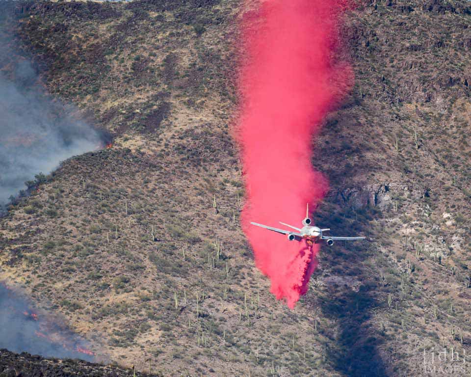
The Bush Fire started on the West side of Highway 87 in Arizona on June 13, 2020.  Drive by strong winds from the SW, it soon spread to the highway median and then crossed to the East side of the highway.  From there, it went on to burn 193,000 acres until it was completely contained on July 6, 2020.
Air tanker drops retardant ahead of fire.  Photo by JDH images.  https://wildfiretoday.com/tag/bush-fire-in-arizona/

Air tankers were extensively used in the initial attack on the fire, and Google Earth images of the fire start location show some interesting features.  These images were taken on June 20, 2020, 7 days after the fire had burned this location.

The fire started on the West side of 87.  Fire retardant strips are visible in several locations.

Where the fire was backing against the SW wind, retardant drops were successful in stopping the spread of the fire.  A small bulge near the top of the image shows where fire crossed the line, but was contained.

Retardant drops on the south side of the fire were not successful in stopping the fire, but may have been instrumental in slowing the fire which allowed it to be stopped at the dirt road.

Retardant drops directly in front of the wind-driven fire were not successful in holding against the onrushing flames.  The fire spread over and around the retardant line in this image.

At another location on the same date, the fire can still be seen actively burning.


Thursday, October 27, 2022

Is Forest Thinning Beneficial for Everyone?

 This Undark article says Pinyon jays are proposed for ESA listing because of forest restoration thinning:

“some bird biologists... are sounding the alarm that even today’s thinning methods degrade pinyon jay habitat. These woodlands are already under extreme drought stress, especially in New Mexico, with predictions for widespread loss due to climate change. And some studies suggest thinned piƱon-juniper forests are less resilient to beetle infestation and drought.


 I participated in a 10-year monitoring study of thinned and unthinned Pinyon-Juniper woodlands in the Manzano mountains.  Our findings were different from those discussed in the study; we found increased soil moisture at thinned plots, which led to richer pinyon nut crops and an increase in pinyon jays.  


However, I'm not arguing that the cited studies are wrong; there may be important site-specific differences between different restoration treatments in different areas.    Some restoration can actually help pinyon jays, we just need to figure out which treatments, and how!

Hopefully, we can all agree that if a treatment isn't making things better for native plants and animals we need to rethink it; just because something is called "restoration" doesn't mean its automatically good.  That's why we need science like this.

Citation.

Wednesday, October 26, 2022

Upcoming Endangered Species Listing Decisions in Arizona 2022-2027

I found a 5-year workplan on the USFWS site and made a list of all of the AZ species that USFWS will make listing determinations for. 

Its pretty interesting to look at what’s coming up.  Lots of talussnails!  But after the Sonoran desert tortoise (which they decided not to list), I think the next big one is the Monarch butterfly.  

Also interesting that there’s no bumble bee species on this list, as I know they’ve been petitioned.  Of course, this could all change as new species are added to the candidate list and priorities change...


FY22

Sonoran desert tortoise

-widely distributed in AZ deserts

- listing decision spring 2022: not warranted


Cactus ferrugous pygmy owl 

-by end of calendar year

https://www.inaturalist.org/taxa/237012-Glaucidium-brasilianum-cactorum

https://www.audubon.org/news/this-tiny-desert-raptor-could-soon-regain-federal-protection


roundtail chub


gray wolf (western populations)


FY23

Joshua tree 


Quitobaquito tryonia


FY24

Monarch butterfly

-widely distributed in AZ

A listing proposal is anticipated by November 2023, with a final listing decision by end of Federal FY2024 (September 2024). 


Las Vegas bearpoppy Arctomecon californica


Pinaleno talussnail Sonorella grahamensis

San Xavier talussnail Sonorella eremita


FY25

Ferris's copper butterfly Lycaena ferrisi

https://www.inaturalist.org/taxa/1360320-Tharsalea-rubidus-ferrisi

ASNF southwest of Springerville


Chisos coral-root Hexalectris revoluta

Sky island mountains


Threecorner milkvetch  Astragalus geyeri var. triquetrus


Grand Wash springsnail Pyrgulopsis bacchus

Kingman springsnail Pyrgulopsis conica


FY26

Arizona toad Bufo microscaphus microscaphus

- widely distributed in AZ

https://www.inaturalist.org/taxa/64982-Anaxyrus-microscaphus


Navajo bladderpod Lesquerella navajoensis

- habitat on Navajo Nation


Yuman Desert fringe-toed lizard Uma rufopunctata


Mojave poppy bee    Perdita meconis 


Bylas springsnail Pyrgulopsis arizonae

Gila tryonia Tryonia gilae

Huachuca woodlandsnail Ashmunella levettei


Squaw Park talussnail Maricopella allynsmithi

-populations are on city or county parks in the Phoenix metro area https://explorer.natureserve.org/Taxon/ELEMENT_GLOBAL.2.114155/Maricopella_allynsmithi


Verde Rim springsnail Pyrgulopsis glandulosa

https://www.inaturalist.org/taxa/111425-Pyrgulopsis-glandulosa


FY27

Morton's wild buckwheat  Eriogonum mortonianum


Pipe Springs cryptantha    Cryptantha semiglabra


Source: https://www.fws.gov/media/national-listing-workplan-fiscal-years-2022-2027

More USFWS lists:  https://ecos.fws.gov/ecp/species-reports

Friday, October 14, 2022

Biodiversity on Prescott National Forest

 How many plant species are there in a geographic area?  Previously, I used iNaturalist to calculate total biodiversity for selected areas.  But this method is just a snapshot of the species currently recorded in iNaturalist.  In some areas, people may have already observed most of the biodiversity, while in other areas there may still be much more to discover.

One way to estimate the total unobserved biodiversity of a geographic area is to look at the timeline of species observations.  If more new species are being observed each year, there are likely still many more species to discover, whereas if the number of new species each year is declining, we may be able to fit a decay function that would predict the total number of species that will ever be observed.

iNaturalist offers a couple of ways to find lists of new species.  As an example, I will use the Prescott National Forest in AZ.

The first method: the API function recent_taxa.

According to this method, there have been 57* new plant species observed on the Prescott National Forest in iNat so far this year.  This is filtered for only research grade observations (quality_grade=research).  There are a lot of new observations by experts that just haven’t been confirmed by other experts. *For some reason this returns the species, genus, and family so to get 57 I subtracted repeated taxa (29) from total new taxa this year (86).

https://jumear.github.io/stirfry/iNatAPIv1_identifications_recent_taxa.html?place_id=130970&taxon_id=47126&hrank=species&order=desc&order_by=created_at&per_page=200&quality_grade=research

The URL code is pretty easy to modify for other places (PNF = 130970) and other taxa (plants = 47126).  Here is more background on API query terms: https://api.inaturalist.org/v1/docs/#!/Identifications/get_identifications_recent_taxa


The second method: download data.

 When searching observations for Prescott National Forest and filtering by plants, iNaturalist returns a page with summary statistics.   This can be downloaded and analyzed in Excel.

https://www.inaturalist.org/observations?place_id=130970&iconic_taxa=Plantae 

 After downloading the data:

1. sort the table from oldest to newest by the observation date column

2. select the whole table

3. use “remove duplicates”, and look for duplicates in only the species name column

The resulting list will show you the first observation of each species.  I then summarized the list by year and created this graph showing the year and number of new plant species recorded in iNaturalist for PNF.  


This method also sometimes returns other taxa than species, so the totals don't quite match between the website, the API, and this method.  Also, this graph is not filtered for only Research Grade observations, but it would look basically the same.  The graph appears to increase over time as more people use iNaturalist to record plant species on Prescott National Forest, up to a peak year in 2020.  Since then the number of new species seems to fall off, although it should be noted that 2021 was a drought year and 2022 isn't over yet.  


Wednesday, October 05, 2022

Biodiversity Phenology

 There are many ways to explore biodiversity using iNaturalist.  One way to study the biodiversity of a geographic area is with phenology:  the science of when things happen.


For example, it is possible to modify the search URL to find observations of plants within 100 km of Dublin, OH, to search for specific months.  The count of observations for each species give some idea of their abundance in that month.


Central Ohio's most common flowering plants in March.

Central Ohio's most common flowering plants in April.

It is interesting to note that the number of observations for e.g. Bloodroot (Sanguinaria canadensis) increase from March to April, but its relative abundance appears to decrease as Dutchman's Breeches (Dicentra cucullaria), Trout Lilies (Erythronium americanum) and other species are photographed much more in April.

Sunday, September 25, 2022

Where is most biodiverse?

 iNaturalist can be used to compare biodiversity in different locations.  

To do this, it is important to allow for different search effort in different areas: for example, a search of the middle of the Amazon might not return many species, not because there aren't many, but because people haven't observed them.

For the U.S., we will assume that search effort is at least somewhat comparable.  We will also look at total observations and divide them by total species to get some idea of the effort required to document a new species in that area.

We decided to investigate my home town in Washington State, Alexandra's home town in Ohio, one of our favorite places: Maui, and our current home in Arizona.

Port Orchard, WA

A 100 km search radius includes most of Puget Sound, the Olympic mountains, and Seattle.

Dublin, OH

A 100 km search radius includes most of central Ohio creeks, woodlands, agricultural lands, and all of Columbus OH.

Prescott, AZ

A 100 km search radius includes canyons and mountains between Flagstaff and Phoenix.


Maui, HI

A 100 km search radius includes all of Maui as well as ocean channels and nearby islands.


Summary Table


According to this analysis, Washington is most biodiverse, followed by Ohio, then Arizona, and in last place is the island paradise of Maui.  

Island biogeography teaches that islands, although unique for their level of endemic plants and animals, should be deficient in overall biodiversity if there hasn't been enough time for biodiverse taxa to colonize or evolve on the island.  This seems to be the case with Maui, which is especially depauperate in insects, given its tropical location.

Arizona, despite its diverse environments, is significantly lacking in Fungal diversity, which could be due to the arid climate.

The American Midwest, with its perfect seasonal growing climate, is remarkably biodiverse, and would probably surpass Washington if this search had included a more varied part of the Midwest with more mountains and/or rivers and lakes.

Washington tops the list as most biodiverse, probably because of the presence of diverse environments, with everything from alpine mountain tops to ocean kelp forests, and everything in between.  This is despite the lower number of insect species compared to a lower latitude place like Ohio.

A caveat to this entire analysis is revealed by the Total Observations in each area and the resulting Observations per Species.  While I had assumed that search effort would be equivalent across the US, it is evident that many more people are using iNaturalist around major cities like Seattle and Columbus.  Arizona is more sparsely populated and has many less observations, and Maui, despite the huge numbers of tourists, is even less populated.  This means that is only takes 20 or 27 new observations (on average) to observe a new species in Maui and Arizona, respectively, while it takes 47 or 72 new observations in Ohio and Washington, respectively, to observe a new species.  So even though Washington has the most observed biodiversity in iNaturalist, it may be easier to find new, previously-unobserved biodiversity in Maui or Arizona.

Thursday, September 22, 2022

Mapping Species Habitat with Appropriate-Sized Buffers

 Previously, I wrote that this Story Map shows small polygons of habitat as buffers around representative observations.  However, the actual locations are not accurate because the underlying observation data has been randomized to protect populations of rare species. 


The first map ("Preliminary Conservation Zones" and "Potential Dispersal Zones" for the American, Rusty-patched, Suckley's, and Western bumble bees) shows the correct kind of critical habitat (buffered observations) USFWS has designated for rusty patch and would likely designate for other proposed species, but the locations are incorrect.  For example, the mapped locations of Rusty patch on that map do not line up to the USFWS GIS for rusty patch critical habitat. 


Some of the other species may be are incorrect as well, depending on whether the data source (GBIF) considers the species endangered and so randomized the locations within a 0.2 degree lat/long box.  That seems to be the case for the Western Bumble bee, but not the American bumble bee. 


The map shows a mix of accurate and inaccurate, specific habitat points. This is confusing and potentially misleading, if the intent is to facilitate conservation planning.  For example, when I zoom to an area of interest, I might think there is no mapped habitat there. But if there is some nearby, I can't tell from if that habitat is or isn’t within my area of interest.


The easiest fix would be to increase the size of the buffers so that they include the entire randomized area (0.2 degree, lat/long) that each point comes from.  A note could say that critical habitat would likely be designated in a subset of those larger polygons based on the buffer size USFWS decides.

Monday, September 19, 2022

Rusty Patched Bumble Bee Critical Habitat


Rusty patched bumble bee range map.

USFWS listed the rusty patched bumble bee (Bombus affinis) as Endangered in 2017 due to a marked decrease in the range and size of populations across the Eastern U.S.  

As one of the first insect species to be listed under the Endangered Species Act, it offers an interesting case study for the way USFWS may approach other insects proposed for listing, including the Monarch butterfly, and numerous other bumble bee species.

From Xerces Society Listing Petition, 2016.

The listing petition states that "the rusty patched bumble bee probably needs floral resources to be located in relative close proximity to its nest sites, as studies of other bumble bee species indicate that they routinely forage within less than one kilometer from their nests ... although in some cases nearly two kilometers ... [It] is likely dependent upon woodland spring ephemeral flowers, since this bumble bee emerges early in the year and is associated with woodland habitats.....Rusty patched bumble bee queens are one of the earliest species to emerge, with observations as early as March and April."

Interestingly, rather than designate critical habitat based on the habitat needs of the species, USFWS chose to designate "High Potential" zones (e.g. critical habitat) as 1 mile buffers, and "Low Potential" zones as 4 mile buffers, around known (since 2006) sightings of the rusty patched bumble bee:


USFWS Map showing "High Potential" and "Low Potential" zones.  


Detail showing example 2x2 mile rusty patched bumble bee "High Priority" habitat in DeKalb, IL from USFWS map.  The buffered area seems to be based on a sighting at Prairie Park, and includes residential and industrial developments.  The only habitat in the area is within Prairie Park.  


USFWS has issued the guidance on whether consultation is required.  For vegetation management activities within the High Potential zones, the guidance provides the following test questions:
  • Is there habitat for nesting, foraging, and/or overwintering for the rusty patched bumble bee in the action area or will the proposed action restore habitat for the species in the action area? 
  • Will the action cause effects to vegetation in rusty patched bumble bee habitat in the High Potential Zone during the nesting period? Effects could occur as a result of mowing, cutting, grazing, prescribed fire, tree removal, spot-application of herbicide, tree clearing, and/or other activities. 

Based on this case example, it seems likely that USFWS will take a similar approach when listing other bumble bee species.  Specifically, it seems likely USFWS will only designate habitat immediately surrounding recently documented sightings, as opposed to using a general habitat model across the species' range.  Then, Section 7 consultation will be required for any activities that disturb habitat during the nesting period (i.e. growing season).

This seems to be the assumption underlying this Story Map, which shows small polygons of habitat as buffers around representative observations.  Note that the actual locations in this map are not accurate because the underlying observation data has been randomized to protect populations of rare species. 

This map of rusty patched bumble bee habitat around DeKalb, IL schematically shows the kind of habitat USFWS designated (i.e. buffered polygons around point observations) but does not show the accurate locations of the habitat because the data used for the map (GBIF) is randomized within 0.2 by 0.2 latitude/longitude rectangles.  

Thursday, September 15, 2022

Mitigation Banking Could Transform the Endangered Species Act

 The Clean Water Act (CWA) --despite its ambiguities-- has the important provision of acre-for-acre wetland mitigation. In other words, the CWA ensures No Net Loss of protected wetlands.

The Endangered Species Act (ESA) --despite controversies over Critical Habitat-- has no automatic provision of no net loss of protected species habitats. Instead, it relies on bespoke mitigations on a project-by-project basis. Most projects are approved with incompletely mitigated impacts to species and their habitats. The result is continual loss of habitat.

Current proposed changes to habitat mitigation could help make ESA more like CWA, moving the ESA toward No Net Loss of habitat. The result would be improved regulatory certainty for projects, mitigation banking opportunities for conservation investors, and better outcomes for listed species.

Environmental Policy Innovation Center's Becca Madsen has more excellent & detailed analysis.

Monday, September 12, 2022

Thistle Misidentification

Thistles are amazing flowers, but there are both native and nonnative invasive species in the Western US.  Some people who try to do good by removing nonnative thistles accidentally kill the native species as well. 

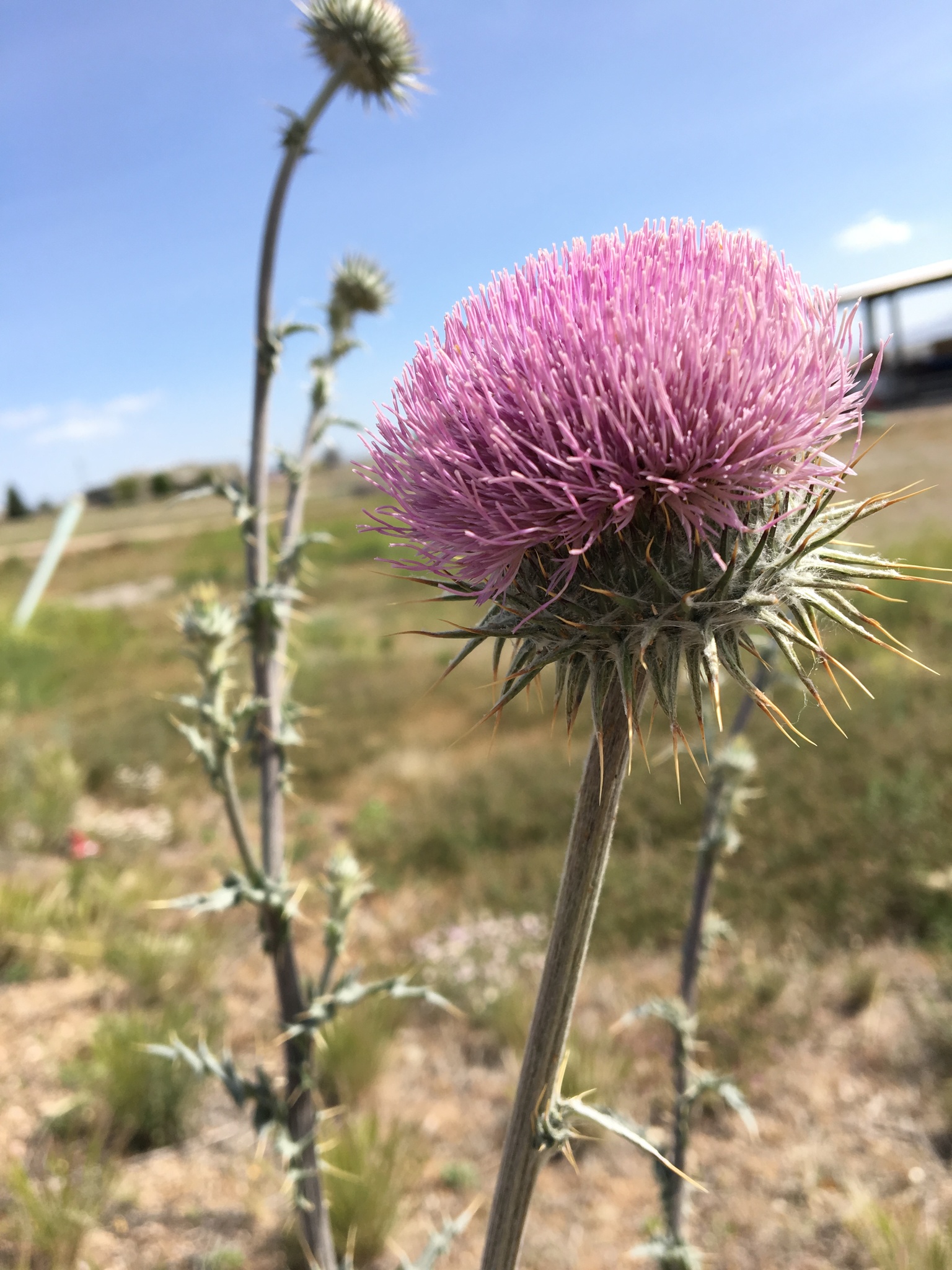
NM Thistle, Cirsium neomexicanum. My photo on iNaturalist. Link: https://www.inaturalist.org/observations/15024423

I worked with an AmeriCorps crew in the Sacramento Mountains (Lincoln NF) that had been removing musk thistles.  But I found out they didn’t know how to tell the difference between native and invasive thistles. 

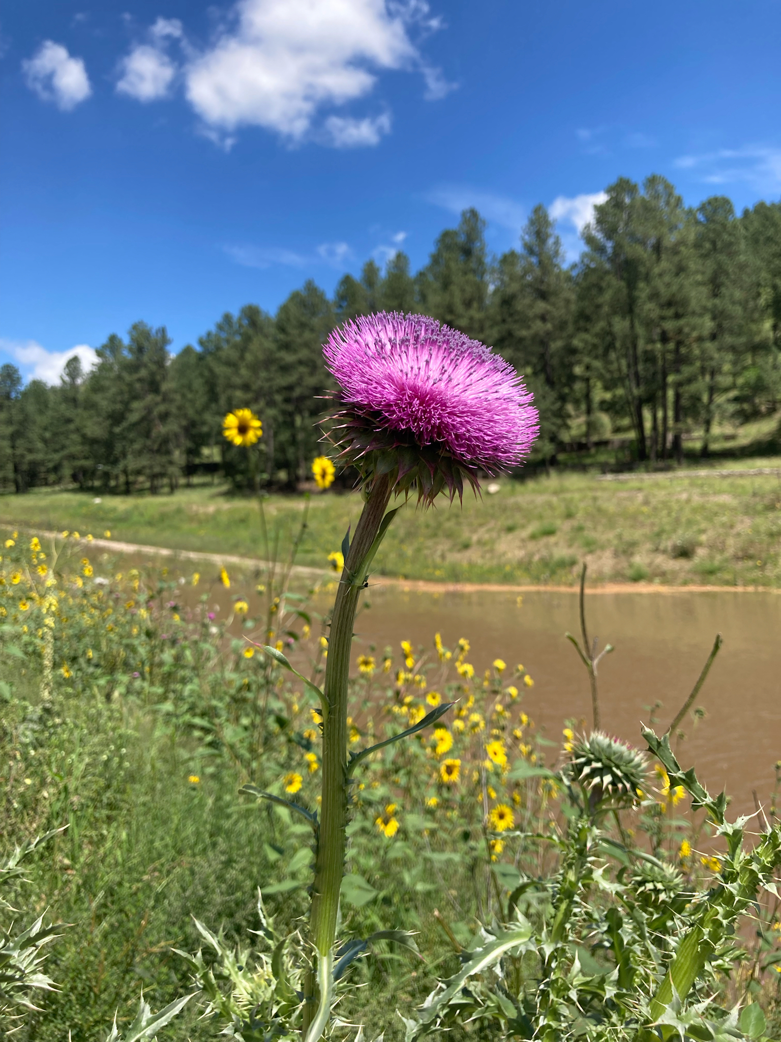
Photo of musk thistle Carduus nutans from iNaturalist user c-guinan. Link: https://www.inaturalist.org/observations/132367683

Even worse, they didn’t even know that there is an Endangered species of native thistle in those mountains!  We investigated and it looks like they at least didn’t kill any endangered thistles, but it could have been really bad. 


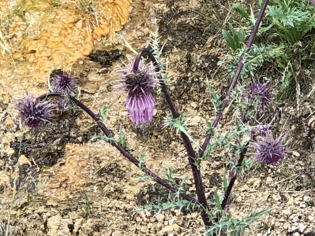
Photo of Endangered Sacremento Mountains Thistle Cirsium vinaceum from iNaturalist user ck2az.  Link: https://www.inaturalist.org/observations/14433149

I’m currently trying to find the volunteers on the Prescott national forest who are pulling up all of the Arizona thistle along popular trails.  Its especially troubling to me when people who are trying to do good by removing invasive species end up destroying native species.

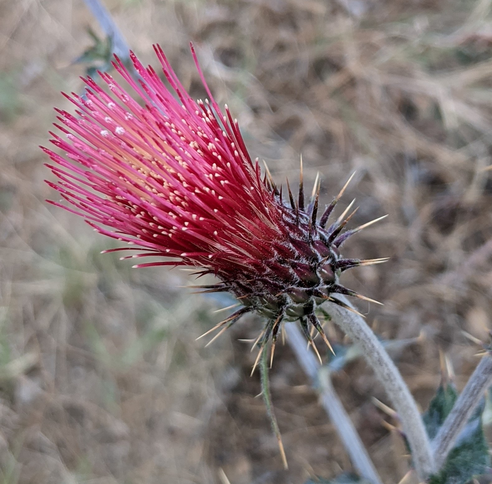
Arizona Thistle Cirsium arizonicum.  My photo on iNaturalist.  Link:  https://www.inaturalist.org/observations/87880049

Everyone who’s done natural resource work has stories of project missteps.  I don’t know how to prevent all mishaps, but talking about these misidentifications is a good first step.

The NM Native Plant Society has a great Thistle ID book written by Bob Sivinski.