Showing posts with label hydrology. Show all posts

Wednesday, July 24, 2024

Cutting Trees for Water: Are Thinned Forests Wetter or Drier?

Forest thinning can be controversial.  Concerned citizens want to know when logging counts as restoration;  can thinning a forest have beneficial ecological effects beyond reducing the risk of stand-replacing wildfires?  Will cutting trees increase soil moisture because there are less "straws sucking up water", or does it decrease soil moisture due to increased windspeed and more sunlight drying out the forest understory?

April 2017 - views of Rogers Lake, AZ overlooking untreated (left) and treated (right) areas.  Photos by Conor Flynn.  Click this link to play with the slider.  


Whether thinned forests are drier or wetter is complicated.  The excellent paper "Adapting western North American forests to climate change and wildfires: 10 common questions" by Prichard et al provides a good introduction to this question:


"Decreasing canopy bulk density can change site climatic conditions (Agee and Skinner 2005). Wildfire ignition potential is largely driven by fuel moisture, which can decrease on drier sites when canopy bulk density is reduced through commercial thinning (e.g., Reinhardt et al. 2006). Reduced canopy bulk density can lead to increased surface wind speed and fuel heating, which allows for increased rates of fire spread in thinned forests (Pimont et al. 2009, Parsons et al. 2018). Other studies show no effect of thinning on surface fuel moisture (Bigelow and North 2012, Estes et al. 2012), suggesting that thinning effects on surface winds and fuel moisture are complex, site specific, and likely vary across ecoregions and seasons."

Anecdotally, some people have noticed springs beginning to flow again after thinning and prescribed fire in AZ.  My research in NM pinyon noted increased soil moisture at thinned sites (unpublished data), however this could be due to the specifics of how thinning was accomplished at those sites.  Thinned slash was chipped and the chips were left on-site without follow-up prescribed fire.

In addition to water quantity, water quality should also be considered.  Prichard et al point out that "Treatments in watersheds that are distant from the WUI and protect municipal and agricultural water supplies are critical to minimizing high-severity fire impacts that can jeopardize clean water delivery (Bladon 2018, Hallema et al. 2018). For example, post-fire erosion and debris flows may cause more detrimental and longer-term impacts to watersheds than the wildfires themselves (Jones et al. 2018, Kolden and Henson 2019)."  However, even carefully managed thinning and prescribed fire can generate excess erosion from new roads, decreased large woody debris, and increased mobility of light charred wood.  Charcoal washing into local lakes can cause fish kills, even when not generated by catastrophic wildfire.  Creating erosion-control structures as part of forest thinning work could help to mitigate these risks.  

Further research is needed to ensure that large thinning projects adequately account for water cycle restoration in addition to natural stand density and fire interval restoration.  

Wednesday, November 20, 2013

Rosemont Mine and the Scientific Method

In today's Arizona Star Opinion Section, Dr. Ostercamp discusses recent hydrologic research about whether the proposed Rosemont Mine would affect surrounding groundwater levels, and how much.

The upshot?  "More research is needed."  A classic scientific result that, in this case, sides with environmentalists' opposition to the proposed copper mine.  I was interested that this result shows how science often works differently from how most people think. Instead of generating facts to aid society's decisions, normal science (and scientists) thrive on ambiguity, controversy, and the unknowability of the world.

I believe that science, as a human institution, should work this way.  I am deeply suspicious of any scientific field with easy answers and a "97% consensus".  Scientific culture harnesses the creativity, jealousy, and competition inherent in human nature when it is most controversial, when there are a plurality of opinions and accusations.  When I hear that, for example, climate change researchers are united behind the IPCC report, I worry that the incentive structure of that field of science has become corrupted; instead of working to prove each other wrong in order to gain fame and fortune, they have all jumped on the same bandwagon to champion their cause.

In the same way that monopolies are bad for capitalism, unified "consensus statements" are bad for science.  This is not to say that I disagree with the IPCC's conclusions.  In the same way that a monopoly might act in society's interest, the IPCC may well be acting in our best interests.  But without dissent and opposing voices there is no guarantee.  Of course, one might argue that monopolies can be efficient; scientific consensus is necessary to accept what we know and move on.  I agree that arguments and democracy are very inefficient and often only result in stalemate, acrimony, and confusion.  Perhaps the "best" way of running an economy or the scientific method is ultimately a political decision?  

Politically, science (as I have described it in the first and second paragraphs) often argues for the status quo, because any change is inherently unknowable and the amount or "further research" needed is infinite; we can never comprehend everything.  So, in its current manifestation, science plays into the hands of industry when industrial processes are already ongoing: this is why Monsanto's fight for GMOs to be labelled "generally recognized as safe" and widely disseminated is so important.  Science would have argued for limitless further testing if GMOs were acknowledged to be a legitimately novel subject of study.  Conversely, science plays into the hands of environmentalists whenever new industrial projects are proposed.  In the case of the proposed Rosemont Mine, scientists would need to comprehensively understand the geology, hydrology, ecology, and meteorology of the entire Santa Rita mountains, if not the county and beyond, before being able to pass judgement on the effects of the mine.

But what about situations where environmentalists and industry would like to work together to advance some project for the good of society?  For example, thinning projects on national forests are badly needed prevent continuing damage to watersheds and ecosystems, as well as human life and property.  But what can science say about the best way to thin forests?  "Further research is needed..."

Friday, July 05, 2013

La Jencia Flash Flood!


Moving at about 5 miles per hour (as judged by floating tumbleweed), the front of the flood (visible here with lots of foamy flotsam) made a roaring sound easily audible at the ranch house.  The brunt of the thunderstorm had passed more than half an hour previous.  Based on cross sections of this reach, the flood was only about 30cm deep, and represented a flow of approximately 50 CFS.  This amount of water may be "bankfull": the bank-side sedges were underwater, the willow got their feet wet, and no major channel geomorphic changes occurred. 

Advancing front of flash flood.

 The next day.


 Flooding along old channel where side canyon empties in.  This channel was abandoned in 2009 when the creek cut through a meander bend.

Wednesday, February 06, 2013

Bankfull Flood on the Haw River, North Carolina


There is abundant evidence of a bankfull flood event on the Haw River, upstream of Bynum, North Carolina.


Let's see what the USGS Gauge at Bynum says.

 A gauge height over 11 feet counts as a flood...and it is more than 7 feet above current flow.  Note that this is a very wide river, so the actual volume was much more than 7 times...according to the USGS calculation, the flow was near 20,000 CFS, over 30 times the current flow of 600 CFS.

How does the compare to previous floods?
This January flood appears to be a bankfull event that was surpassed in 2008 (the first year of record for Bynum), 2009, and 2010, (but not in 2011 or 2012).  Many of these large floods happen in the early spring, perhaps when the heavy rains fall on an already-saturated watershed.

This is what happened the week of January 13th.  On top of the previous week's rain, there was significant rain on Monday the 14th and Wednesday the 16th.  The storm continued into Thursday, bringing more than an inch of thunderstorm rain (and snow) on top of the saturated landscape.  The Haw river flow peaked soon thereafter, in the early morning hours of January 18th.

Friday, November 06, 2009

USGS concludes 2006 was 1,000-year flood near Tucson


Floods are described in terms of their recurrence interval. A 10-year flood has a 1 in 10 chance of occuring each year. Many engineers and flood planners work with 100-year floods, since this is approximately the length of accurate and reliable observations in the West. However, much larger events can, and do, occur.

After studying the aftermath of the floods that wiped out Sabino Canyon in Tucson in 2006, the USGS has concluded that the event was virtually unprecedented. By dating geological deposits, they estimated that the floods that swept down most of the West-facing canyons in the Santa Catalina Mountains were probably on the order of a 1,000 year flood.

However, with climate change and associated land cover changes on the mountains, that interval may no longer hold. Pearthree, section chief of AZGS Environmental Geology, warns, “increasing fire frequency on the steep slopes of the Santa Catalina Mountains due to invasive species like bufflegrass may result in greater runoff, and possibly increased debris flow frequency, in the coming decades.”

Details, including an map.

Other recent flash floods.

Wednesday, November 04, 2009

Quivira Coalition Water Symposium


Quivira Coalition Annual Conference


Speakers I enjoyed:

Peter Warshall
A-->B Horizon (CF. History of Greece)
some grasses like B horizon (maybe Hairy Grama?)
1,000 years to restore
Vigil network data
Leopold was against "drop-in science"

Larry Schmidt
--> channel incision
lack of sediment incises below stream
-->too much water (culverts)
-->too much slope
-->wildfire causes no cover, hydrophobic soil, runoff w/out sediment
results in incised channel (sediment hungry)
positive feedback between reduced cover, dendritic incision, and loss of wateravailability

Burchard Heede Alkali Creek 40 years
showed that landscape incision could be corrected by creating a grass-lined waterway
induced meandering can also cure incision

Bill Zeedyk and Van Clothier
streams can erode bottom OR sides
*anticipate* stable form
*nudge* in that direction

e.g meander multiplier is usually between 10-20: 10 for wet sedge meadows, 18 for dry ephemeral channels
Questions:
utility of BF-FP width ratio?
how does flow become channelized (versus dispersed)
why aren't incising channels self-correcting? are they?
structures needed b/c of lack of woody debris?

Saturday, September 26, 2009

Calibrating Bank Full Measurements Using Regional Curves and USGS Stream Guage Data

Bankfull is important to fluvial hydrogeomorphology (HGM) because it often determines the shape of the channel by moving and depositing sediment. Bankfull (BF) is defined as the high water level that recurs every 1 - 2 years, but measuring it in the field involves using multiple indicators in a 'preponderance of evidence' detective-style approach.

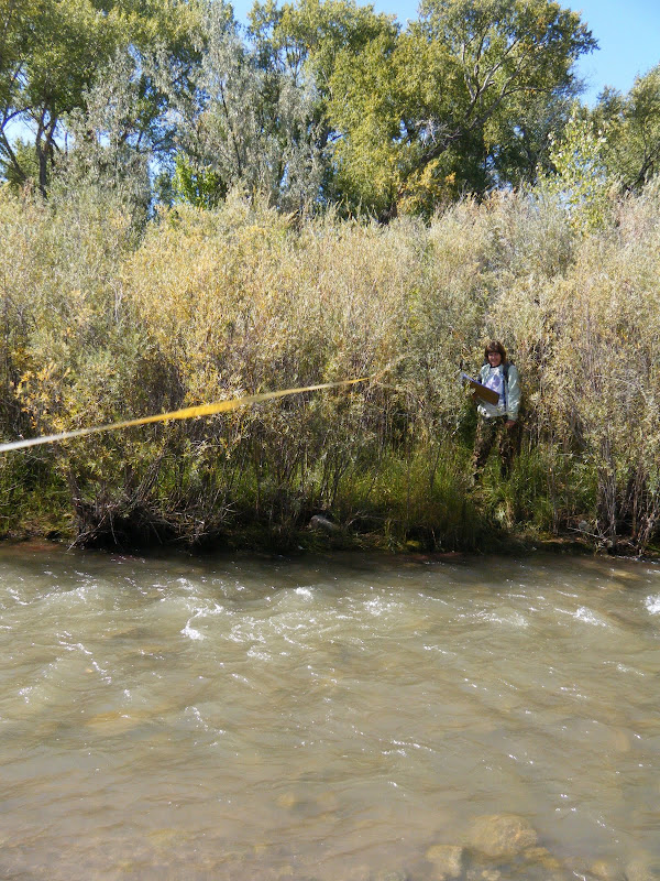
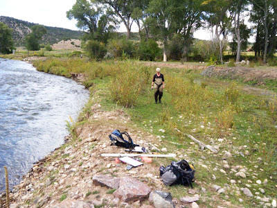
Most plants that cannot tolerate saturated soil conditions for days at a time, like Alders, will not grow below BF, while willows and cottonwood can. Also, the top of point or side bars can indicate the height of BF, but on the Rio Embudo, near Dixon NM, BF indicators were contradictory and hard to find. Is BF just a few centimeters above the base-flow water, or are all the willow below BF?
From Rio Embudo at Dixon, NM Hydrology Analysis
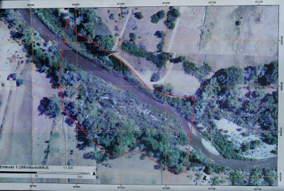
A number of bars and scour features at different heights further compounded the mystery. It was time to seek out other clues. One source of potential indicators was our aerial imagery, which was taken during Spring runoff, 2008:
From Rio Embudo at Dixon, NM Hydrology Analysis
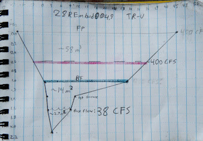
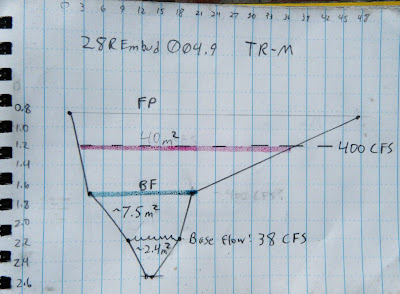
The point bars at bottom right are bisected by a side channel that is several feet above the base level today. That means BF must be at least that high, and would probably inundate most of the willows. Corroborating this, the landowner reports that the willows are indeed flooded almost every year. But exactly how high is BF? To gather more data, we surveyed three channel cross sections, or transects (TR), noting the heights of the major terraces.

TR-Upper
From Rio Embudo at Dixon, NM Hydrology Analysis


TR-Middle
From Rio Embudo at Dixon, NM Hydrology Analysis

Tr-Lower
From Rio Embudo at Dixon, NM Hydrology Analysis

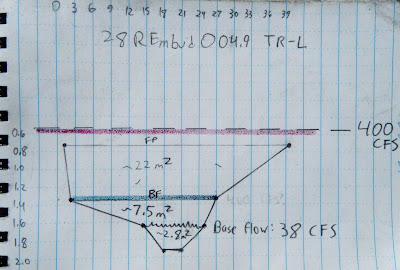
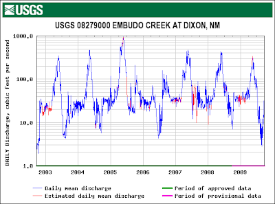
On each of these cross sections we marked where the current base flow water level is, where we think BF is, and where we think Flood Prone (FP) might be. To check these guesses, we correlated those heights with flow data from a USGS gauge just downstream:
From Rio Embudo at Dixon, NM Hydrology Analysis
From this graph we could see that the high water level with recurrence every 1 -2 years is about 400 cubic feet per second (CFS). We could also see that the current flow was about 38 CFS. If the Rio Embudo is flowing with 38 CFS today, how high would a BF flow of 400 CFS be?

between the flow today and BF flow. To figure that out we might need to correct for any changes in the velocity (feet/second). Manning's Equation:

shows that velocity V is proportional to a constant, u, inversely proportional to a coefficient of friction, n, varies to the 2/3 power of channel cross-sectional area, R, and to the 1/2 power of slope, S. Since neither slope nor the constant would change, we can discount them and focus on n and R; n will likely increase because the willows will act like a series of giant combs, increasing friction, and R will also obviously have to increase. For example, doubling the height of the water would multiply that term by 1.6. Unfortunately, coefficients of friction need to be experimentally determined, so we can only guess at n. To make things easier, I decided friction would also increase by a factor of 1.6, to exactly cancel out R. In other words, I don't think the velocity would change by much.

So it is a simple matter of geometry to calculate the cross-sectional area that would correspond to 400 CFS on our cross sections (red lines on the cross-sections, above). Without exception, this height is higher than our field-determined BF (green lines on the cross-sections, above) and, at least for TR-L, even higher than our FP height.

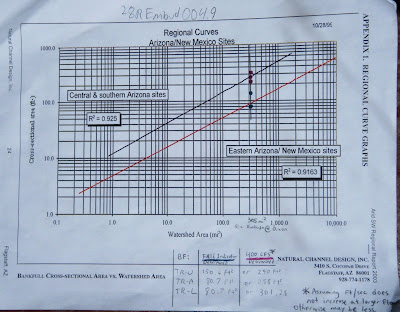
But is this right? Are we getting closer to the truth? To check, we can calibrate our answers for the Rio Embudo against data published by Natural Channel Design on a large number of other Southwestern rivers:
From Rio Embudo at Dixon, NM Hydrology Analysis
I plotted both our field-determined BF cross-sectional area (green points) and the USGS-determined BF cross-sectional area (red points) on the regional curve above. The green points seem to fall on the line for New Mexico, while the red points fall on the Arizona line, corroborating our field measurements and casting doubt on the USGS. However, the watershed above Dixon is very impermeable and could behave more like AZ than NM. I think the true value is probably somewhere in-between the field and USGS values.

This line is probably as close as any to Bankfull:
From Rio Embudo at Dixon, NM Hydrology Analysis

Evaluating Restoration Potential at Taos-area Streams

We use a four-tiered scale to rate restoration potential, basically A, B, C, D:

A is fine, possibly excepting some irrigation
B is for "needs beaver!", and/or stop grazing
C needs instream structures and earth moving equipment to restore functionality
D can't be helped

From Natural Heritage New Mexico - Taos Streams

Rio Costillo. Upstream landowner's home is within flood-prone area and would certainly be an impediment to any restoration effort, while downstream landowner's stretch has been dredged. D
From Natural Heritage New Mexico - Taos Streams

Rio Fernando: A thriving beaver population has created extensive wetlands composed of Typha and Salix exigua, but completely extirpated Populus from the reach. A (maybe plant cottonwood)
From Natural Heritage New Mexico - Taos Streams

Santa Barbara Upper: A main channel circumvents the beaver ponds and side channels and appears somewhat channelized, with low habitat diversity (and hence few fish). What is causing the main channel to bypass beaver dams and downcut? A?
From Natural Heritage New Mexico - Taos Streams

Rio Pueblo: Irrigation returns from irrigated pastures along the North; humans have attempted to replace breached beaver dams and drying beaver ponds with rock-and-plastic "fisherman's dams". B

For more site descriptions, click on the links above.

Friday, August 01, 2008

Bankfull Discharge

Bankfull Discharge is (often) defined as the average high flow of a river that recurs about every two and a half years. Sometime bankfull discharge can be easily determined from the high water mark and local topography, whereas in other cases it is somewhat of an abstraction. Here's a chart of the yearly high flow (in CFS), for the Red River, near Questa NM, since 1915. It gives a good idea of the variability inherent to streamflow. What do you think the bankfull discharge is?

Monday, March 10, 2008

On the Importance of Meandering

Streams love to meander for reasons that are simple to understand yet profound to ponder. When a stream meanders around a bend the outside water must travel faster than the water on the inside of the curve. This increased speed leads to increased erosion and the bend becomes wider. As the bends become wider the overall length of the stream increases. Also, because the stream is eroding the landform more evenly, the overall grade is reduced and the water slows down. This decreased speed combined with increased length vastly alters the hydrological characteristics of the watershed, contributing to aquifer replenishment and filtering.

Changes in the Mississippi river's meanders:Meanders are a good thing that happen naturally. Sometime humans want to help the process along, especially for streams that have downcut and linearized (straightened). Water has momentum and will bounce off an oblique line of in-stream rocks, known as a vane, toward the opposite bank, starting an oscillation that can become a full-fledged meander.
Vane closeup showing rocks, stabalizing posts, and planted willow:
Several parallel vanes create an induced meander:
The banks that form behind vanes are first accretions of large boulders, then smaller rocks, and then small particles, all stacked somewhat like oranges at the supermarket. Because of the gradient of particle dimension, these banks act to soak up moisture from the stream through capillary action and are therefore great places to plant trees.
The old channel can still be seen seeping out from under the bank on the right while the new induced meander flows around to the left.:
Another view of the old channel seep (now on the left) and the new channel (on the right) flowing into a pond:
A dam can create ponding, which also slows water. The ratio of riffles to still water is an important measure of hydrological health, and for streams of this size and location the ratio should be close to 1:1. Even large rivers should often have this ratio; for example, the Columbia river, before it was artificially dammed and its watershed logged, held vast log jams stretching from bank to bank creating huge lakes. The easiest and most natural way to create ponding is with beavers, a keystone species that create habitat for hundreds of other species.

Unfortunately, there is not enough vegetation to support a beaver colony on Las Huertas. Creating an artificial pond with a wicker weir backed by an infill dam is a good short-term solution.
Eventually the dam will fill in with sediment, raising the stream bed and creating good streamside habitat. At present the pond helps raise the water table as well as store surface and subsurface water. The weight of the water in the pond pushes water further into the alluvium around the dam, supporting our revegetation project. Eventually there will be enough trees to support beavers and a self-sustaining ecological-hydrological system.

Another way to create ponding (and slow water) is a Zuni Bowl, an in-stream depression lined with rocks. It is named in honor of the Pueblo Indians in the Southwest who invented many of these water-control structures hundreds of years ago.
Slowing water is one way of slowing erosion. Another is stabilizing slopes.

The slope pictured below is divided into two regimes. The lower pitch is an equilibrium arrangements of small particles. This slope is also known as the angle-of-repose. The upper pitch is a nearly vertical cliff where disturbances can cause catestrophic failures.
The slope pictured below is composed of alternating regimes of angle-of-repose and cliffs. The slope erodes from the bottom and then unstable slopes just above that collapse, and so on. The progression of erosion from bottom to top is an example of effects moving "upstream": erosion at the mouth of the river affect the headwaters even though water only flows downstream. Even though stones can only roll downhill, their downhill absence propagates uphill to affect the perch of still-higher stones. Thus , what happens in a valley can determine the shape and slope of the mountains around it. By slowing erosion here we determine the shape of mountains.

A plant's roots can often form a barrier to the progression of erosion by holding together soil in a steeper slope. However, unless the root causes of erosion are addressed (e.g. with vanes) eventually soil will be washed away from the roots and/or the entire plant will be undercut.
A combination of engineered solutions and revegetation can work together synergistically to slow erosion. Indeed, since water velocity is determined by slope, decreased erosion is itself responsible for slowing water and hence slowing further erosion. The key to influencing such feedback systems is knowing where to interfere. Often restorationists find themselves faced with the bemusing problem of wanting to work simultaneously both downstream and upstream of the target stretch, asking themselves the question, "does the water above push the water below or does the water below pull the water above"?

Friday, February 15, 2008

I. Toilet to Tap

comment on Facing the yuck factor. How has the west embraced water recycling? Very (gulp) cautiously. Peter Friederici. HCN p.10 September 17, 2007

Americans are different from most people on the planet. We have indoor plumbing and can turn on fresh, drinkable water any time we want. But the combination of the two may be our undoing. We don't pay a quarter of our salaries and spend hours waiting in line to get potable water, and maybe because of that we have abused our privilege. Now that the rivers are drying up in the West, cities are looking to new sources of fresh water. But where?

Ironically, "San Diego has both a water-supply and a water-disposal problem." Why not use the water in need of disposal as a new supply? Maybe because the slogan is "Toilet to tap"?? Sustainability advocates in Tucson (myself included), recently tried to pass a ballot initiative (Prop.200) with just such a slogan. Our reasoning: if Tucson doesn't want "toilet-to-tap" we had better start limiting growth now, before that's our only option. The opponents of the measure (ie proponents of growth such as developers) argued that Tucson would never need to divert wastewater into drinking water. But, just weeks after Prop.200 went down in flames (after mafia-style threats from the developers), amid reports of more drought, the Tucson papers began suggesting that perhaps Tucson really does need to start looking into the idea, after all.

Of course, all water is recycled eventually. Tucson is currently "recharging" its aquifer with wastewater. As the wastewater seeps through hundreds of feet of sand the hydrologists claim it will be cleaned enough to draw back up a well for drinking water. Las Vegas uses an even more direct filtration approach: "Los Vegas alone discharges roughly 60 billion gallons of wastewater a year some miles upstream of its own water intake -- a feat of urban engineering that would seem to prove that most of what happens in Vegas really does stay there."

All of which just points up the rationale San Diego used in its (failed) attempt to utilize wastewater: "We can have a lot more monitoring and control if we oversee our own reclamation than if we're relying on a river with a billion gallons of recharge [in the Colorado River] from other sources every day." Bruce Reznik, executive director of San Diego Coastkeeper. Just as no place is truly a wilderness "untrammeled by man" anymore, so too no source of "clear mountain springwater" is truly without some contamination, e.g. some "clear mountain streams" high in Colorado have enough man-made chemical estrogen mimics to feminize fish.

Friederici, a journalism professor, has written a great article that touches on some very deep issues in the interplay of science, technology, and society; E.g. the trust ordinary citizens place in their own biased perceptions versus the scientific analysis of professionals. The article suggests that that "perceptual shortfalls" in ordinary citizens might in fact be a reasonable, precautionary reaction to the belated discovery of the harms of rGBH in milk and endocrine disruptors in plastics. Without the ability to "see" contaminants that affect them ordinary people may have to rely on the history (story, narrative) of their water to determine quality rather than the quantitation (appeal to authority) of scientists.

-

A simple solution the article overlooked: *abandoning our water-treatment infrastructure* and giving in to the bottled water craze. This water crisis is caused by the average American household sending 150 gallons of fresh, drinkable water down the drain every day. If we could use untreated or sub-potable treated water for most domestic needs and bottled water for drinking and eating we would eliminate the source of the dilemma: overconsumption. However, if, in the end, the punishment for being spoiled Americans is drinking our own toilet water, perhaps there is some justice in this crazy universe after all.