 The Sonoran Desert and its six subdivisions.
Friday, August 22, 2008
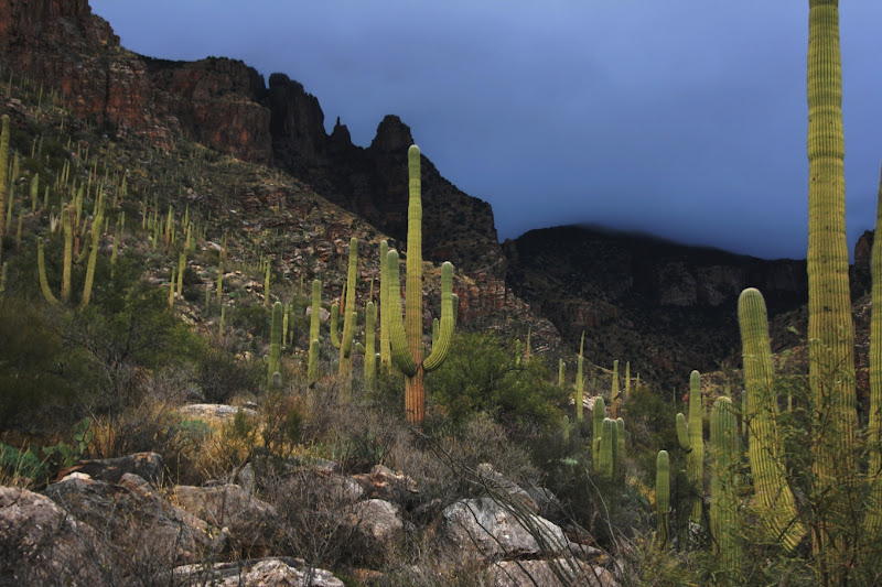
The Sub-Tropical Sonoran Desert
My goal for the winter is to explore the extent of my home ecosystem: The Sonoran Desert and its six subdivisions.
The Sonoran Desert and its six subdivisions.
Sunday, August 17, 2008
Protecting the rare Bog Birch
Sponsored by Albuquerque Wildlife Federation, NM Wilderness Alliance, and Native Plant Society of NM with support from NM Environment Department and Los Amigos de Valles Caldera


THE PLACE: The Valles Caldera National Preserve was a private ranch until 2000,
when Congress created it from the "Baca Ranch" in New Mexico's volcanic Jemez Moun-
tain Range. This 89,000 acre property is studded with eruptive domes and features
Redondo Peak (11,254 feet). Though open to the public, access to the preserve is
strictly controlled. Coming on this project is a great opportunity to stay on the preserve
without charge and see areas not generally available to the public.

THE PROJECT: This project occured at a fascinating location — Alamo Bog! See
the Earth shake under foot as you walk across the bog (Hydrosol). Smell the fumes of
Purgatory (sulfur gas bubbling up through opal-colored acidic pools). See sphagnum moss.

Alamo Bog is home to the rare Bog Birch (Betula pumila(?)). This is the species' only known
location in New Mexico. We built small exclosures to protect the largest patches, each with about 40 to 60 plants. The structures exclude elk, which have heavily browsed the bog birch. Digging holes, setting untreated fence posts, is not permanent, but nothing is. Our restoration work is premised on the idea that future management changes will render our structures superfluous.
Interesting species also include a couple Orchids, Checker Mallows (Sidalcea neomexicana), and Sphagnum Moss, a rare species this far south!
Interesting species also include a couple Orchids, Checker Mallows (Sidalcea neomexicana), and Sphagnum Moss, a rare species this far south!


Thursday, August 14, 2008


Monday, August 04, 2008
Upper Rio Grande Watershed: Rio de los Pinos to Conejos River

Flanked by the Conejos River and Rio de los Pinos, this watershed includes Pinorealosa and Osier Mountain, along with many excellent creeks (named and unnamed), alpine meadows, and river bottoms. Controlled burns and selective logging seem to be keeping the woodland open and healthy, while fire or beetles have left enough dead and downed timber to create unnavigateable thickets, quite conducive (necessary and sufficient) for unfragmented, Wilderness landscape.
Thin, filamentous, and/or deeply pinnatifid leaves, everything with prickles, spines, or a dense covering of hair (tomentous) -- but not many poisonous. Hairs serve to insulate as well as defend. ... In the wetlands, poisonous and fleshy plants dominate. Elk and bear, fire and grazing, Rorippa, Mimulus, Penstemon, Geum, myriad rodents scurrying away in all directions, fawns hiding breathless in the grass, hellebores and corn lilies, the 'Umbel of God', ululation, mountain thunderstorms...
The coastal fog of California, gentled by a 1,000 miles travel. I heed the thunder, and elevate the advent of rain above dull annoyance. This morning, I climbed the cliffs above our campsite. When I reached the top I felt like crying. Don't know why. Looking out over the watershed I understand the pattern. All water runs downhill. There is a band of trees from a lower line where it is wet enough to grow to an upper line where it is too cold to grow. There is a line in-between those two, above which precipitation exceeds evaporation. All rivers originate above this line, in their Headwaters.
I was always thinking of new, clever, ways of getting ahead of Nature, ahead of myself, beyond lightspeed and Saturation, entropy, Capacity. Rainbows multiplying from the first: Asgaard, Bridge to Heaven. But why does it curve back to Earth? Everyone sees a different shape and distance, depending on their perspective. The kind of rain mosquitoes can still swim through to sting. Lightening and that particular sound of the thunder rolling off of the peculiar and idiosyncratic topography up-valley.
But what if the world refuses to be ordered by the human mind? We know honeybees can be trained to show preference between human faces, but will they ever understand them? Then how too will we ever understand our world? Words are useless if we rely on them to a fault, if natural variation is continuous and nonlinear, yet we expect it to conform by our contingent, evolutionarily-derived logical architectures and cognitive biases.
On the backbone of the continent, the Genesis of the Southwest; a looking-glass world, mountains in every direction, but the brooding presence of the Great Plains felt in the passes opening between. At times we thought we were in Kansas, or safe away in our beds dreaming, but we were in the San Luis Valley, ripening in the sun.
You have driven up and down the mountain valleys, the flanks that lead up from below or down from above, the highways and streams of rivers and clouds. You have stood, still, in the center of the valley, under Blanca, for days. Transfixed interest, blossoms like dollar bills in the breeze. You have climbed high up where there is more air than land, yet still cannot seem to breathe enough and the mountain says enough and the Thunderstorm says Enough and you flee their mutterings and grumblings
Storms billow on surrounding mountains, then range over the landscape. Powerful rain, thunder and lightening on into the night...sigh... San Juan rainstorms. The next day the storms grow but, despite our hurry to avoid them, only blow for early Evening Entertainment, and on into the night. Next day, storms brush by, delivering a soaking with bits of hail mixed in. These storms build on the San Juans, blow low over the valley --but nothing can slow them until the Sangres, where they slide silently up the crest, lick their salty skins, run a tongue along sharpened teeth, and watch the wounds of mankind's world.
Where have all the willows gone? The heart of the landscape dug out, munched, passed, trampled dirt. The magic and will to live that flowed wild, healthy, worshipful. Destruction AND Growth. Unsimplified. Wet, unique.
All land in the West is "wetland"; fear not. Although nothing fits into categories anyway, each consciousness, attuned to an unique understanding, attempting an unbiased account of who-knows-what for someone else. Under the roof of the world, wet with the aspen, the carex, and the rivers; mountain ridges diverge until they peter out, rivers seek their breathren and converge until they become one with the ocean. Flowing water flows together - it lubricates itself; whereas water soaking into sponge, expands -- it flees the mutual weight of multitude.
Oh now gentle rain, Conejos River hopping along...who understands?
Sunday, August 03, 2008


Comanche Creek Restoration Weekend

(click here for more photos)
Comanche Creek watershed is located in the Valle Vidal Unit of the Carson National Forest, an area that was historically logged, grazed, and mined. These anthropogenic effects on the land have negatively impacted habitat for the Rio Grande Cutthroat trout – New Mexico’s state fish! Partnering with a wide range of other organizations and agencies, The Quivira Coalition and the Albuquerque Wildlife Federation has led a long-term stream restoration project at Comanche Creek aimed at restoring trout habitat. The 2008 field season is especially important given an announcement on May 13, 2008 by the US Fish & Wildlife Service that the Rio Grande Cutthrout trout be formally proposed for protection under the Endangered Species Act.
For more information about the types of restoration work completed: http://www.comanchecreek.org/images/links/189-Comanche_II_Quarterly_Report_08-2007.pdf
Saturday, August 02, 2008
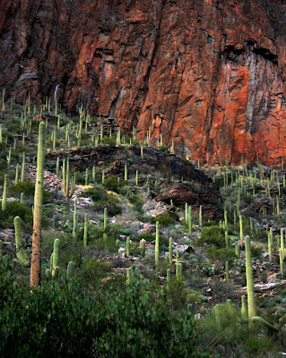
20 Years' Phenology, Santa Catalina Mountains, Tucson
"One remarkable legacy dataset...is the record of plant species in bloom along the Finger Rock trail in the Catalina Mountains north of Tucson, Arizona, collected by Dave Bertelsen. The data represent an enormous effort. Covering a major elevation gradient, a 20-year period, and a comprehensive record of all species in bloom, they contribute invaluable information at a scale very few individuals would ever attempt."
Using this dataset, scientists demonstrated clear patterns in the seasonality of alpha diversity (species richness) of species in bloom across an elevation gradient (Crimmins et al. 2008). This diversity was strongly influenced by precipitation at lower elevations and by temperature at upper elevations. In addition, over the course of the study, average summer temperature showed an upward trend, as did the number of species in bloom in summer at the highest elevations."
A discussion of the importance of "citizen scientists".
Canonical Seasons
How many seasons are there?
 Where does our myth of these canonical seasons come from?
 When do the seasons start and end?
"Thailand lies within the humid tropics and remains hot throughout the year. The annual average temperatures is from 28-35 °C, ranging in Bangkok from 35°C in April to 17°C in December. There are three seasons: cool season (November to February), hot season (April to May), and rainy season (June to October). During the month of August, there might be rains and the weather is not too warm, with temperatures from 24 to 35 degrees Celsius."

the five seasons of the sonoran desert

Or is it 8?
Great Sand Dunes National Park
In Colorado, the elemental forces of the desert and mountains meet: wind, dominant in the scoured aridlands, here locked in struggle with the water of the alpine mountains. There is a line above which precipitation outweighs evaporation and it is from these lands that all rivers flow.
Wind picks up the sand and deposits it in a crook of the mountains arrayed about, who in turn let down the flow of the headwaters of the Rio Grande, great snake that cuts through a thousand miles of canyonlands to reach the Sea. The flow smooths the land incessantly like an overprotective mother.
Here is my high water mark, from whence I, too, will flow back to the desert. I have found the headwaters.
Wind picks up the sand and deposits it in a crook of the mountains arrayed about, who in turn let down the flow of the headwaters of the Rio Grande, great snake that cuts through a thousand miles of canyonlands to reach the Sea. The flow smooths the land incessantly like an overprotective mother.

Here is my high water mark, from whence I, too, will flow back to the desert. I have found the headwaters.
Lithic Mulch
I have done field ecology throughout New Mexico and Arizona -- but no matter how long I live in the Southwest it seems there is always more to discover...I recently discovered the existence of lithic or cobble mulch gardens while perusing a report by Richard D. Periman featured in "Desired future conditions for Southwestern riparian ecosystems: Bringing interests and concerns together," produced by the Rocky Mountain Forest and Range Experiment Station, and have spent an enjoyable morning reading some of Dale Lightfoot's papers about sites in Northern New Mexico and the Safford Valley of Arizona. Both are areas where I have spent considerable time, and I am now wondering if I have unknowingly visited some of these prehistoric gardens. I am especially interested to learn how thoroughly these type of sites have been studied...from my natural history work I understand that sometimes the best preservation strategy for valuable sites is to keep them undocumented, but I wonder if there is a GIS layer of inventoried sites? These archeologists deserve congratulations on bringing this remarkable phenomenon to light; discoveries like these may help transform how we ecologists think about the Natural Range of Variation (NRV) in these areas.
"Lithic-mulched features have not been thoroughly studied, in the USA or elsewhere. Details are spotty...The research by Maxwell and Anscheutz in the Ojo Caliente Valley in northern New Mexico is very good. The Fish’s work on Hohokam Arizona is good. Berlin et al. 1977 are quite thorough, as is Engel’s work in the Andes. Much remains to be done at all other sites associated with lithic mulching. I understand your comment about leaving things undocumented. It’s best, sometimes, though in cases where features are on the verge of being obliterated, as were many of the gravel mulched plots I worked on in 1988-89 south of Santa Fe (1990 dissertation and subsequent articles), it’s best to record what you can, when you can (i.e. salvage archaeology).
I know of no GIS inventory related to lithic mulching anywhere. I have no plans on the immediate horizon to work on this topic in the U.S. Southwest, but I didn’t have any plans to work on the Safford project, either, until Bill Doolittle approached me about joining his project and I could clearly see a way to contribute to the project."
Friday, August 01, 2008
Bankfull Discharge
Bankfull Discharge is (often) defined as the average high flow of a river that recurs about every two and a half years. Sometime bankfull discharge can be easily determined from the high water mark and local topography, whereas in other cases it is somewhat of an abstraction. Here's a chart of the yearly high flow (in CFS), for the Red River, near Questa NM, since 1915. It gives a good idea of the variability inherent to streamflow.  What do you think the bankfull discharge is?
 What do you think the bankfull discharge is?
Subscribe to:
Posts (Atom)