Showing posts with label puerco. Show all posts

Wednesday, September 23, 2009

Rio Puerco, NM: BEFORE and AFTER

The furthest downstream restoration site is doing well. Note how the roads have revegetated.
From Rio Puerco Restoration Evaluation - September 2009


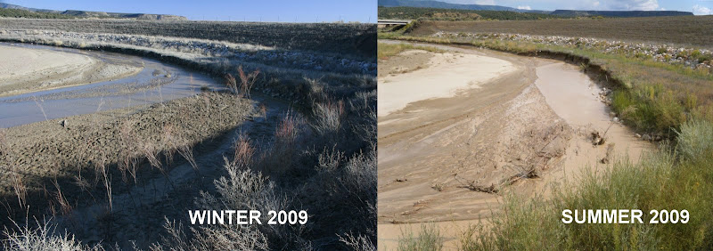
The large berm in the background is the "remeander" dam that was built a couple years ago to push the Puerco back into its original channel. In the foreground an In-Stream Willow Planting (ISWP) immediately after it was planted (left) and then after a single growing/flooding season (right). This planting did not incorporate wattles. It has largely washed out as the river channel continued its lateral migration toward river right. A large amount of new erosion is visible along the right side of the channel, which is exactly what this planting tried to prevent. Unfortunately, it is working against the natural migration of the river.
From Rio Puerco Restoration Evaluation - September 2009

The same ISWP, looking upstream. The main channel is now flowing (and cutting) right along the bank. The point bar on the left has widened.

From Rio Puerco Restoration Evaluation - September 2009

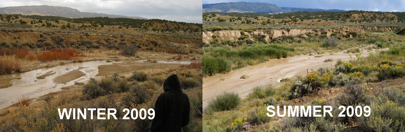
These photos show the Guardian's plantings immediately downstream from the bridge. This old channel is now receiving flow because of the remeander. It is a healthy channel with an active floodplain. All of the cottonwoods and willows received overbank flooding from the summer monsoons, and did very well. Its a real jungle down there!
From Rio Puerco Restoration Evaluation - September 2009


These photos show an ISWP on Guardian's State Land. It is the middle of three such ISWPs on State Land. The channel through this reach is downcut and straight, almost like a ditch, and the plantings sought to induce meanders. While the plantings didn't wash out, it doesn't look like the willow are doing very well; in this wet year the bottom of the channel may have been too wet for them. Looking further downstream, one can see sedges growing into the channel, forming a natural meander pattern. Planting sedge plugs may be more effective below bankfull.
From Rio Puerco Restoration Evaluation - September 2009


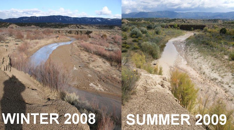
These photos show the downstream area of the Guardian's State land that was planted in 2008. The ISWP from 2008 is not quite visible under the large cut bank in the center distance. The development and change of the river's channel and associated point bars are visible in the foreground.
From Rio Puerco Restoration Evaluation - September 2009

For more information and more photos, click on one of the photo links above.

Sunday, May 25, 2008

Trespassing on the Rio Puerco

Trespassing on the Rio Puerco
[at 120 CFS]


We put in just before the large culvert. Its top was filled with a colony of mud swallows' hanging igloo nests.


Guerrilla Rafting: n; Risking Life and Limb to Reinhabit your Local Wilderness.

Its simple. Find your local watershed and see how far it will take you. Dreams of floating to the sea? Forget it. Few undamned and diverted rivers remain. But you'll be surprised at what you can cover in a day. Here's a sample from our kayak on the Rio Puerco, through backyards and jungle thornbush.

big falls ... portage or run it?


Strainers.


picturesque views: Spiders showered down on us when we shook low branches. Squirrels scurried from branch to branch, flycatchers, tanagiers, and orioles...


The 'Sloppy Rapids' portage

Photos of Rio Puerco (from Cabezon Peak)


Thursday, May 08, 2008

Rio Puerco: the Poster Child of Eroded Watersheds

[NOTICE - This Road Not Maintained by New Mexico State Highway Department]

* Frederick Jacson Turner, father of modern American history, wrote persuasively that the frontier (where less than 3 people lived per square mile) defined American life, but that it closed in the 1890's as the country filled up with emigrants and settlers. But the land is emptying out again, as chronicled in Richard Manning's Grassland. The old world ecology and thinking brought by the Anglo settlers is failing in the drylands of the American West and the people are leaving, the roads abandoned. Despite massive government subsidies, the remaining ranchers and farmers have less and less to stand on every year. Populations in most rural counties peaked in the early 1900's and have declined ever since. The exodus that started with the dust bowl has continued unabated, as has the soil erosion and ecological damage.
[Could this be restored to its original ecology of cottonwood/willow bosque and gallery forest?]

Now, The Good News: "This is a search for the unknown...Now the sun is here, and he simply watches the land year by year to see what happens, waiting for the next clues as to what the nature of this place might be...It's like a ratchet in that we take the first turn, then back off and let nature take a turn, as we listen and watch as closely as possible, knowing that we are not so much rebuilding nature in these places as nature is rebuilding us. With each turn of this ratchet, nature reveals a bit more of itself to our science."
[SUN]

"In some real ways, the effort to re-find the landscape, which is the same as the effort to re-attach our lives to the land, is a religious quest, and it makes sense to consider it that way.

[Erosion (so bad it took 2 photos to fit): The bridge on the left used to span the river chanel. This is why the road is closed. Nature fights back. ]

"...it is difficult to imagine what we have learned. Annual topsoil loss to erosion here in some years totals one hundred tons per acre, or an inch of topsoil removed every 1.6 years...the topsoil the grass had built was thought to be so deep as to be inexhaustible..." p.165 from Grassland, Richard Manning.
[Dead willow, killed incidentally with herbicide "friendly fire"]

Mutilated and mutated willows, the taste of heavy metals on the tongue: this place has been sprayed. "Many in federal agencies ignore the connection between livestock grazing and weed invasions. Since they deny the role of livestock grazing, they seldom reduce the number of livestock allowed to graze public lands, even in areas where weeds are a major problem. Agency personnel prefer using herbicides and biocontrol agents to eradicate the weeds rather than trying to prevent the invasion of weeds in the first place." From "Comrades in Harm: Livestock and Exotic Weeds in the Intermountain West", Joy Belsky and Jonathan L Gelbard. in Welfare Ranching, Earth Island Press
[Rio Puerco Watershed: this area could be a State]
John Wesley Powell recommended that states and counties' boundaries in the American West be demarcated based on watersheds, since water is the natural form that power takes on the land...today, as witnesses of the modern West's "Water Wars" can attest, more and more political boundaries are being created or determined by water rights.

The Rio Puerco is oft mentioned as an example par excelance of some of the worst erosion in the United States. Once the "Breadbasket of New Mexico", the Rio Puerco watershed is now given as a common example of the degradation that can befall such formerly productive areas through mismanagement and ecological ignorance. Enhanced rates of erosion on the "dirty river" are the cause and effect of downcutting in the soft alluvium that formerly supported such bountiful harvests. Unstoppable headcuts and devegetated banks, combined with a climate shift that creates more "flashy" events (which, of course, are also caused by devegated uplands that lack competence and capacity to absorb rainfall, leading to sheetflow and immediate runoff that feed back to cause even more erosion...
[Landslide]
The Rio Puerco Management Committee lists several causes of erosion, such as (over) grazing and the placement of the new highway. As you can see from this photo essay, the war between the road and the river is not over yet. However, much of the battle has already been lost, and the country abandoned without roads. The downstream is reachable only by unimproved dirt roads and crosses some of the remotest parts of the state.
[Fenceline showing effects of grazing, on the right, where thickets of sagebrush dominate]

Thursday, April 24, 2008

Today is National Arbor Day on the Rio Puerco

If we are marked to die, we are enow
To do our country loss, and if to live,

The fewer men, the greater share of honor.
We would not die in that man's company
That fears his fellowship to die with us.
This day is called National Arbor Day.
He that outlives this day and comes safe home
Will stand a-tiptoe when this day is named
And rouse him at the name of Arbor.

He that shall live this day and see old age
Will yearly on the vigil feast his neighbors
And say, "Tomorrow is National Arbor."
Then will he strip his sleeve and show his scars,
And say "These wounds I had on Arbor Day."

Old men forget, yet all shall be forgot,
But he'll remember with advantages
What feats he did that day. Then shall our names
Be in their flowing cups freshly remembered;
This story shall the good man teach his son.

And gentlemen in Graduate school now abed
Shall think themselves accursed they were not here,
And hold their manhoods cheap whiles any speaks
That planted with us upon National Arbor Day.

Sunday, April 20, 2008

Jobsite Puerco II: an Ode

stranded on another triangle of sand
wedged between river, mud, and fence
sky, machine, and trees

After all the city folk and designer ranchers on polysyllabic horse breeds had left, the river was silent.
A wind died and the sun shone along the edge of the sky girdling cloud and lit the world anew.
The meadow lark, who had scolded our transgressions against its favorite olive tree, was quiet.
Creation happens every day and those who camp out know the important events of the day are measured in the stillness of the quotidian sunrise and sunset.

(Cow I)
(Cow II)
(Cow III)
...as infinite passion and grandeur bathed my face in God's (why not say it?) loving beatitude, I understood the beauty in the complexity written on his face in tattered streamers of cloud, now dimpled, here undulating, lurid yet calm and innocent.