Advances in efficient, broad measurement of soil moisture are needed to understand plant stress response to drought. Crop growth and phenology can be predicted (link) with accurate modeling of soil-plant-atmosphere interactions. These dynamics are also crucial for advances in meteorology, since most rain that falls in the U.S. is recycled rain that has already fallen and evaporated at least once before, but often several times. Accurate prediction of rainfall will continue to elude meteorologists until soil moisture can be measured and predicted.
Soil moisture is critical for advancing plant and atmospheric sciences, but the fact that different measurement techniques yield different values points to the fact that soil moisture is essentially an abstract idea. While the water content of soil would seem to be straightforward, whether you calculate volumetric or gravimetric water content, and whether you consider chemically- and physically-immobilized water or only plant-available water (field capacity minus permanent wilting point) matters a great deal.
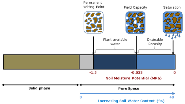
Diagram source.
Spatial and temporal scale also matters. Do you want an instantaneous point measurement, or a daily weekly average for an entire county’s drought status? Picking the right tool for the job means understanding the streghths and weaknesses of the entire gamut of technologies capable of reporting soil moisture. This article will start with traditional in situ point measurement techniques and continue to review broad-scale soil moisture modeling and remote-sensing efforts.
 |
| from Shuttleworth 2013 |
Small-scale measurement
can be accomplished using point-sampling with portable soil moisture probes,
such as TDR and traditional (active) neutron probes. Of course, any discussion of soil moisture measurement techniques would be incomplete without mentioning the gravimetric method, or simply weighing a soil sample wet and then dry. But as with the other point techniques, this method can only measure hyperlocal conditions and must be replicated and averaged to inform landscape-scale management.
TDR, or time-domain reflectometry, uses the
electrical properties of soil and water to calculate volumetric percent soil moisture. For most soils, excluding those with very
high organic matter (OM>10%), the TDR method without calibration provides
water content in the range from zero to 50% with accuracy better than
1-2%. While calibration and new TDR such
as TRIME-TDR can improve accuracy by a factor of 10-100, the amount of
microscale variability in soil means that these point measurements must be
replicated dozens to hundreds of times to build up a picture of average site
moisture. Microvariability can be important when precipitation preferentially flow along soil heterogeneities such as roots, textural changes, and bioturbation pathways. Buried probes that use the TDR
techniques, such as the Stevens Hydroprobes I used in my graduate research, are fixed in place and are therefore severely limited by their inability to average site variability.
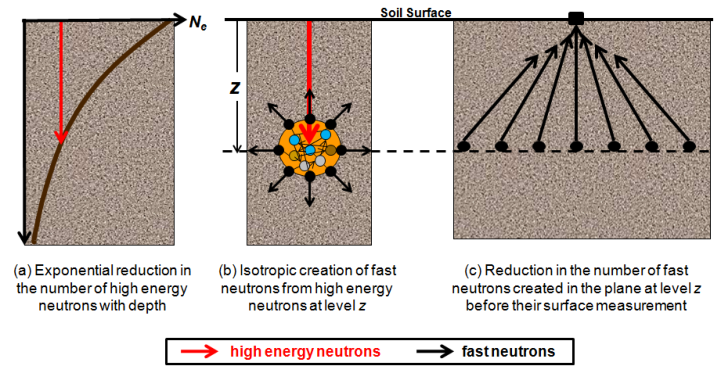
Traditional neutron probes work by bombarding the soil with
high-energy neutrons and recording the number of neutrons emitted by the
soil. Hydrogen absorbs neutrons so the
amount of H2O can be calculated. This
technique solves many of the problems of TDR, but the sensors are expensive and
the measurement still must be repeated several times to measure field soil moisture.
-
Meso-scale measurement can now be accomplished using the new COSMOS (Cosmic-ray Surface MOisture Sensor) program to measure whole ecosystem moisture. Neutron moisture probes have been around for decades but COSMOS uses advances in particle-physics technology to increase sensitivity enough to rely solely on the background cosmic radiation as a uniform source of neutrons. This advance makes possible, for the first time, instantaneous field-scale measurement of soil moisture.
These new sensors were originally deployed in 2010. They have the potential to revolutionize studies of soil moisture because they are the only technique to measure soil moisture at scales between the hyper-local point measurements and the kilometer-swaths of satellites. They also are the only soil moisture probe that can account for water stores in living tissue. According to Hydroinnova, one company that makes these $10,000 units, the measured soil footprint is 86% within 350 meters and the effective measuring depth changes with soil moisture, from a maximum of 70 cm in completely dry soil, to a minimum of 12 cm in saturated soil.
 |
| Source. |
While these sensors are few in number and relatively widely dispersed, they offer a whole new picture of soil moisture at the landscape level. They are the only truly effective direct measure of soil moisture at the hectare level, and can be used to better calibrate the informational products discussed below. However, as with all techniques, COSMOS must also be calibrated to take account of different soil types and changes in vegetation.
-
Large-scale
measurement of soil moisture can be accomplished using proxies, satellites,
models, or some combination of techniques.
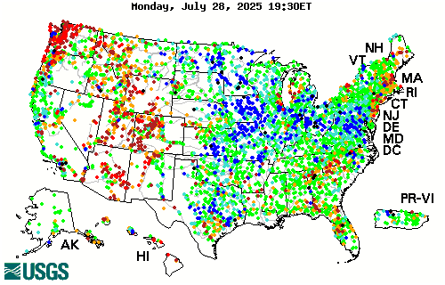
River flow data can reveal how much water is running off or through the soil from watersheds, so using a site like the USGSstreamflow network is a good proxy for large-scale short-term drought and deluge.
River flow data can reveal how much water is running off or through the soil from watersheds, so using a site like the USGSstreamflow network is a good proxy for large-scale short-term drought and deluge.
The current best methods for estimating large-scale soil
moisture are the Drought.gov model products, which include the Palmer Drought
Severity Index, soil moisture index, etc.
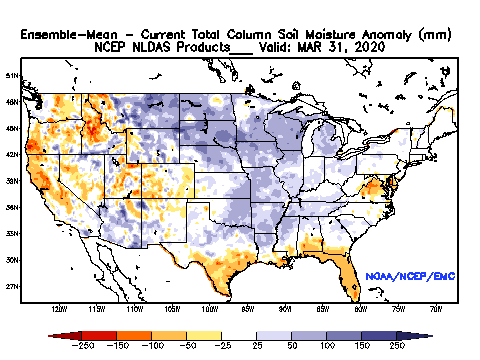
The Calculated Soil Moisture Anomaly is calculated based on
observed precipitation and temperature.
Soil moisture, evaporation, and runoff for the entire US and globe are then
modeled based on observations from a small area of eastern Oklahoma. While this method is clearly biased, it is the best available.

The National Land Data Acquisition System is developing a more accurate model of soil moisture that incorporates soil textural properties and average percent vegetation (which impacts evapotranspiration). The precipitation data used in the model is at approximately 25km resolution, interpolated to 13km grid cells:
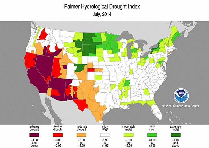
Palmer Drought Indices are similar to soil moisture
models in that precipitation, evapotranspiration, and runoff are used to
calculate remaining water balance. There
are long-term (Palmer Drought Index (PDI) and Palmer Hydrological Drought Index
(PHDI) indices that measure changes in groundwater and reservoir levels, and
short-term indices (Palmer Z Index and Crop Moisture Index (CMI)) that affect
agriculture during the growing season.

No comments:
Post a Comment