Saturday, July 12, 2008

Know Your Barbed Wire

Often, in tramping about the Western States, the intrepid naturalist may find themselves waylaid by the manufacture of man. Rather than merely an occasion for pain and anger, this encounter can also be a learning experience.

Most people can guess slickwire from barbed, but how many know the entire taxonomy of man made dolorimeters?Here is my rough key to this vexing subject:

a.Single Strand....b
b.Slick Wire [not depicted]
bb. Glidden's Twist
aa. Double or more strands
b.Ribbon Strand...Untorn Ribbon
bb. Double Strand...c
c. Barb is of similar wire, usually twisted around strand...d
d. Barb is twisted around both strands...e
e. Barb is three pointed...Burnell Hook Around
ee.Barb is one or two pointed...f
f. One pointed...Preston's Horse Wire
ff. Two pointed...g
g. Barb wrapped around both strands together....Brotherton's Barb
gg. or Barb wrapped around both strands one at a time...Decker Spread
dd. Barb is twisted around a single strand....e
e. Barb is four pointed... Shinney's "4" Point
ee. Barb is two pointed, common...Baker's Flat Barb
cc. Barb is otherwise, not same wire as strand
d. Barb is metal plate...Stubbe Plate [rare]
dd. Barb is small plate or flat nail....e
e. Barb is twisted around strand...Scutte's Plate
e. Barb is tied to strand...Kelly Diamond Barb

Friday, July 11, 2008

The Monsoon has begun (in Tucson)

The monsoon has begun in Tucson:
Source.This NOAA graph shows dewpoint, a measure of humidity. The blue line for this year is above the average, red line, and passed the 54 degree cutoff in early July. The monsoon is somewhat arbitrarily defined as any period of three or more consecutive days when the dewpoint is 54 degrees or above. In Tucson this kind of moisture only happens during the monsoon, when the wet tropical air pushes north. More info.

The rainfall so far has been above average as well. This graph does a good job of showing the variability of rainfall between cities that are less than 100 miles apart. When it comes from isolated thunderstorms, sometimes they hit you, sometimes they miss you.

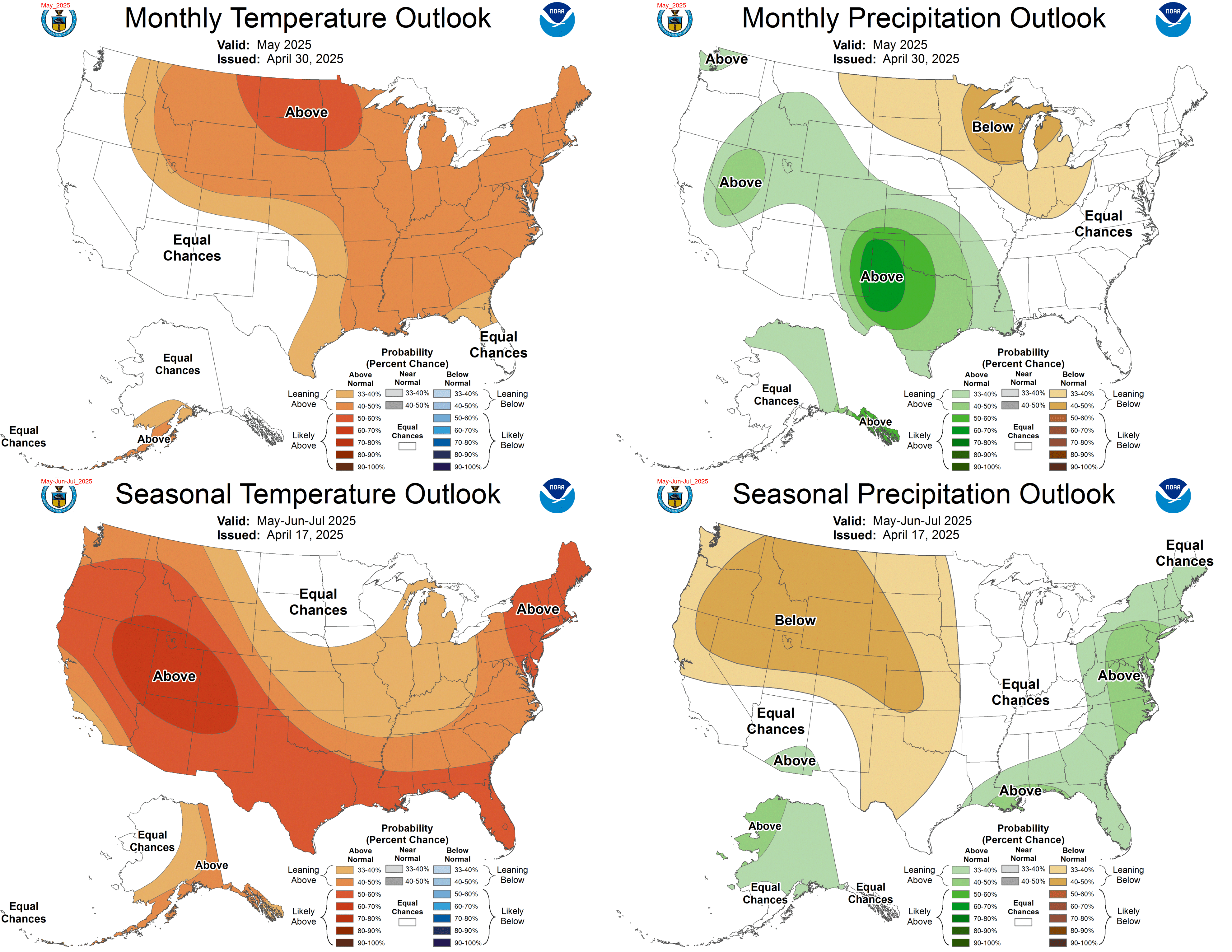
The rain has not yet helped out New Mexico and Texas (source), but the climate forecast is for New Mexico to get a good amount of moisture over the next month:
Source.

Tuesday, July 08, 2008

Geology of Carnero Canyon

The Map Room. This is where most of our adventures start.
View up Carnero Canyon toward Hell's Gate, beyond which lies our cabin.
There is pillow lava here, scattered about, but especially in the next canyon over.
Penitente Canyon and the view toward the San Luis Valley and Sangre de Cristo Mountains.
Awesome columnar jointing on the South side of the Hell's Gate
North Side.

Back side.

Friday, July 04, 2008

Upper Rio Grande Watershed: The Poso and Los Mogotes


"...driving across these llanos for days, solitary pinon and juniper gnarled and twisted and thickened, like baobobs almost, and the antelope / gazelle bounding away, outdoors dawn to dusk , khaki outfit, pith helmet, driving across the plains for days, looking at the summits; heading toward them but then it starts to rain and the mud becomes too thick: fishtailing across the road, saying 'I'm sorry' to all the plants, the erosion. Eventually, the sound of the engine turning off, the door opening, both feet sinking deep into the mud, the finality of the car door slamming in the sudden, rainy, darkness.

Thursday, July 03, 2008

Rock Garden in the Serengetti

Wetlands: those areas that are saturated or inundated with surface or groundwater at a frequency or duration sufficient to support -and under normal circumstances do support- a prevalence of vegetation typically adapted to life in saturated soil conditions.


Friday, June 20, 2008

Southwest Exploration: A Timeline and Bibliography

The more I study ecology, the more I need to study history. Everything from the extinction of the paleolithic megafauna through the grenshorizont of peatland bog studies (shift in peat formation two to three thousand years ago as the midwest became wetter and cooler) to the presence or absence of bufalo (Bison bison bison) in the Arid West....Ecology is paleoecology, which is forensic and contingent on largely unknowable past events. But without that past the changing movie of life is only a single strobe, an event, a stained glass window that we can look at but now through. This perspective is important for science, but equally important for public policy. We can't protect what we've already forgotten.

Below is a partial list of early explorers and colonists of the American Southwest, especially New Mexico, which has a 500+ year written history. We desperately need an ecological historian to compile these original observations, translate and condense, collate, draw conclusions, and eventually inbed it all in a google earth kml layer, like the Mannahata project.

This is a New Mexico centric list, prepared with much help from to William Goetzmann http://www.nps.gov/history/history/categrs/explr/biblio-g2.htm and Ruth Marie Colville, "La Vereda: A Trail through Time."

1537 Cabeza de Baca seven year trek from Texas to Sea of Cortez, fording the Rio Grande "breast high".
Journal: unreliable "recounting"
Book: Cyclone Covey, ed. And trans., Cabeza de Vaca's Adventures in the Unknown Interior of America, Univ. of NM Press, Albuquerque, NM, 1993.

1540 Francisco Coronado two years exploring Rio Grande Valley as far north as Taos, east to Kansas, west [in]to the Grand Canyon.
Journal: ?
Book: Coronado, Knight of Pueblo and Plains, Univ. NM Press, by Herbert E. Bolton, Albuquerque, NM, 1964
Book:[?]Pedro de Castañeda, The Journey of Coronado, repr., Dover, San Francisco, 1990,

1580 Rodrigues expedition: Fray Augustin Rodrigues and Captain Francisco Chamuscada. Rio Grande valley east to Pecos River
Journal: "Relaciones"

1582 Espejo party rescue mission: Antonio Espejo went east beyond the Manzano Mountains, west to ZUni and Hopi, as far as Flagstaff, then back home along the Pecos.
Journal: Diego Perez de Lujan

1590 Gaspar Castano de Sosa illegal colonization: went up the Pecos river to Pecos Pueblo
Journal: Castano de Sosa.
Book: "A Colony on the Move" by Albert Schroeder and Dan Matson.

1598 Don Juan de Onate colonization, settled at head of Espanola Valley.


1776 Escalante Expedition from Santa Fe, through SW Colorado, SE Utah, and NE Arizona.
Book: Bolton, Pageant in the Wilderness: The Story of Escalante's Expedition to the Interior Basin, 1776, Univ. of Utah,Salt Lake City, Utah, 1950,


1806 Pike Expedition: Zebulon Pike
Journal: "The expeditions of Zebulon Montgomery Pike to headwaters of the Mississippi River, through Louisiana Territory, and in New Spain, during the years 1805-6-7
Book: Donald Jackson, ed., The Journals of Zebulon Montgomery Pike With Letters and Related Documents, U. of Oklahoma Press, Norman, OK, 1966.
Book:Elliott Coues, The Expeditions of Zebulon Montygomery Pike, 2 vols., Dover, NY, 1987.

1821 Fowler Adventure to eh Sources of the Rio Grande
Jounral: Cous, E. (editor) 1965 The Journal of Jacob Fowler: Narrating an Adventure From Arkansas Through the Indian Territory, Oklahoma, Kansas, Colorado, and New Mexico, to the Sources of the Rio Grande Del Norte, 1821-1822. Ross & Haines, Inc., Minneapolis, MN.

1846 Kearny-Emory expedition. US Mexico Boundary Survey. Lieutenant W.H. Emory. Arkansas, Del Norte, and Gila rivers
Book: Ross Calvin, ed., Lieutenant Emory Reports: A Reprint of Lieutenant W.H. Emory's Notes of a Military Reconnaissance, U. of NM Press, Albuquerque, NM, 1951.
Book: William H. Emory, Report on the United States and Mexican Boundary Survey, 3 vols., 34th Cong. 1st Sess. H. Exec. Doc. 135, Serial 861-63, Washington, D.C., 1857-59, and repr. William H. Goetzmann, ed, 3 vols., TSHA, Austin, TX, 1997.
Book: John Russell Bartlett, Personal Narrative of Explorations and Incidents in Texas, New Mexico, California, Sonora and Chihuahua, Connected With the United States and Mexican Boundary Commission During the Years 1850, '51, '52 and '53,, 2 vols., Appleton, NY, 1854, repr., 2 vols., Rio Grande Press, Chicago, IL, 1965.
Book: Dawn Hall, ed., Drawing the Borderline: Artist-Explorers and the U.S.-Mexico Boundary Survey, The Albuerque Museum, Albuquerque, NM, 1996, P.B.

1849 Washington Expedition to make peace or prosecute a war with the Navajo
Book: Navajo Expedition: Journal of a Military Reconnaissance from Santa Fe, New Mexico to the Navvaho Country Made in 1849 by James H. Simpson, Durwood Ball, Frank McNitt

1851 Sitgreaves
1853 Whipple
1854 Parke
1854 Pope
[misc ]
see Herbert E. Bolton, Spanish Exploration in the Southwest, 1542-1706, Scribner, NY, 1916, repr. Barnes & Noble, 1995, ...

David Weber, The Taos Trappers, the Fur Trade in the Far Southwest, 1540-1846, U. of Oklahoma Press, Norman, OK, 1982.

Ralph P. Bieber, ed., Exploring Southwestern Trails, 1846-1854, Clark, Glendale, CA, 1938, William H. Emory,

Sunday, June 15, 2008

Colorado Natural Heritage Program (CNHP)

"For in the end, our society will be defined not only by what we create but by what we refuse to destroy." Every state in the U.S. has a Natural Heritage Program (NHP) to comprehensively and systematically monitor biological diversity.
Colorado's NHP GIS computer models select points of special interest based on aerial and satellite imagery. We follow GPS maps to the sample point,
lay out plots to focus our attention at different scales from the microscopic to the landscape.,
collect plant specimens and soil samples as well as analyze ecosystem processes and integrity:
Long summer days in the field.

Saturday, June 14, 2008

Exploring the Rio Grande Headwaters: San Luis Valley

The Rio Grande drains the Southern Rocky Mountains and meanders more than 2,000 miles through the desert Southwest before reaching the Caribbean. Spanish explorers followed this river to its headwaters more than 400 years ago.
However, the Spanish were notoriously poor scientists, more interested in searching for the Seven Lost Cities of Gold than understanding native ecosystems. Even after the U.S. purchased this area in 1848, and despite more than a hundred years of U.S. exploration and documentation, much of this vast area remains unknown and (relatively) undisturbed by Homo industrialis.

I've set out this summer with Colorado's Natural Heritage Program to explore the Headwaters of the Rio Grande with a top-notch, interdisciplinary team of scientists from across the country.

The Rio Grand's headwaters drain from the San Juan Mountains and the Sangre de Christo Mountains into the vast alluvium of the San Luis Valley. This valley, the center of our research, can be thought of as either the southernmost Rocky Mountain park or the northernmost New Mexican valley.
At 7,500 feet this floodplain is a mix of alpine, wetlands, desert, and farmland. Coming from sea level it is continually astonishing to pause and gasp for breath in the center of an agricultural valley where the nearest mountains are 30 miles away. These high plains support a diverse and unique assemblage of plants and animals, with pronghorn antelope feeding in the alfalfa fields, buffalo competing with cows in the sagebrush rangeland, and elk and bear foraging along the periphery.
Our HQ is marked on these maps, a swanky cabin safely nestled in an out of the way canyon on the western rim of the valley. To get to this alpine oasis you first drive past the endless center-pivot irrigation systems of San Luis Valley, than upwards past La Garita through Sheep pass, where the rounded granite boulders shelter pinon and juniper. You are now entering Carnero Canyon, whose narrowings and widenings sequentially reveal a lush cottonwood bosque, then Ponderosa woodland and finally Aspen groves and mountain meadows.

The "Back 40" (square miles):

*Since the cabin is off the grid this post was beamed up via satellite.