italisize scientific names
snow and hills in Arizona winter:
warming sun, purple hands in the snow & shade
Madrean oak to pinon mixed conifers
how many species of oak? and species we don't even know
sample in pockets
pinus edulis
apache pine englemanii
mexican pinyon pinus cembroides
chihuaha pine? pinus leiophylla
Ponderosa
doug fir
white pine pinus strobiformis
sycamore
alligator juniper
steep steep slopes still with soil on them
in some places, thick oak duff
overlays silt and rocks over bigger rocks and boulders and bedrock
exposed in channels and on pinacles
raccoon faced white elipses
blue colored breast
darker blue on dorsum than back
same blue makes crest color protude through white head
arrow shapped fat end over eyes
(sagital crest on forefront of head )
eye circle bigger than eyes is white
raccoon faced?
insect casings exoskeletons left behind after metamorphisis
thalictrum and gallium near trickling pools
stinging nettle near Sylvester Spring
round sedges (scirpus), rorripa
exclosure around the seeping proliferation: out of the reach of
raging floods, stable ecosystems contrast with high-disturbance
\
sylvester had stinging nettle and white pine
(pinus strobiformis)
kent spring, at the apex or azimuth, a frozen stalagmite
and bog with the foot-thick grape vine
springs boxed and improved "fish and game"
white breasted nuthatch
pinus leiophylla chihuaha
geranium
arbutus arizonica (ericaceae... heather the grown up form of ) like arbutus
symphoricarpous oreophilus mountain or roundleaf rotundifolius
ericaceous shrubs in the artic tundra
rhus trilobata on west facing dry hillslopes
Hoffmansegia glandular pea vine there, to
littleleaf sumac
rhus microphylla fruits small, red-hairy, {ital}
bear grass nolina microcarpa
banana yucca, Yucca baccata
parry's and shott agave (mescal and amole)
red pink ball things
green horn beetle 2mm-4mm
horn downcurved
galls we saw today
lemons in the trees: hollow dry bug galls
perforated ball of Sycamore seeds
red tiny balls
caccoon with a hole
pinecone skeleton twigs twisted together to make backbone and ribs
intricate engineering
concave sycamore with hollows
juniper stumps convex, many-trunked
grassy hills under
aligator juniper blue "bloke" oak
ecology
grape vines common near springs
swaying 30-40 feet overhead
crawling over oaks
some are a thick as 8 inch
complex webbing
abundance and habit
-------
no cottonwood in wash
close, steep sides
bedrock confined
maiden pools? dried up
arizona rosewood vauquelinia californica
southwestern coralbean erythrina flabelliformis growing around summit, blue "bloak" oak,
a
black phoebe
ventana canyon over stream
dodonaea viscosa called uopbush
hopbush covered burn sites and common at a certain elevation
-------------
romero pools
coursetia microphylla along rough rock trail
towering saguaro
past them to the first shady clefts
oak and fern,
then onward to flowing water over bedrock
dodea cover the site of a 2003 fire now with 10 foot luxuriant growth, hop bushes swaying in the golden light
Wednesday, October 14, 2009

Sunday, October 11, 2009
The Magical North Central Texas that Used To Be

North Central Texas is composed of three major ecosystems, the Cross Timbers, Black Prairie, and Fort Worth Prarie. Less than 150 years ago, sparkling streams were abundant with trout, perch, and catfish...and alligators! Indeed, Kendall (1845) found alligators along the San Gabriel in the southern Blackland Prairie as "too plentiful for any useful purposes." Black bear were also common, along with mountain lion. Brooke (1848) reports gray wolves as far east as McLennan County, ocelot in bottoms of Brazos River near Waco in McLennan County. The last jaguar record was a large male killed in Mills County (Lampasas Cut Plain) in 1903.
Other vanished creaturs out of this Noah's Ark world include river otter, ringtail (a cat-like creature), badger, javalina (collared peccary), bison, pronghorn antelope, turkeys, and prarie chickens. Many of these animals still persist in zoos or mountains out west, but some cannot be found anywhere on the planet. For example, both the ivorybilled woodpecker and the carolina parakeet, once found near modern day Dallas/Ft. Worth, are extinct.
Estimates of the destruction of the Blackland Prairie ecosystem range from 98% (Hatch et al 1990) to 99% (Riskind and Collins 1975) to more than 99.9% (Burleson 1993). Some of the last remnants can still be seen at the Nature Conservancy's Clymer Meadow Preserve. Slightly more Fort Worth Prarie and Cross Timbers survive. Dyksterhuis (1946) studied relics of the Fort Worth Prairie, and, surprisingly, Cross Timbers are still one of the largest relatively unaltered forest vegetation types in the eastern United States (Stahle &Hehr 1984), but there are more in Oklahoma, for example, Pontotoc Ridge Preserve. Examples of old-growth Cross Timbers forests in North Texas are found in Comanche County (Leon River), Tarrant County (Fort Worth Nature Center), and Throckmorton County (Nichols Ranch).
Prairie remnants are threatened by eastern red cedar (Juniperus virginiana) and cedar elm (Ulmus crassifolia) because of a lack of natural fire. Results include reduction in broad-leaved plants and increased abundance of grasses. (Diamond & Meins 1993). Over much of the slope-lands, as muich as three feet of soil have been eroded, exposing barren rock where once was prairie soil (Hayward &Yelderman 1991). So, although remnants remain, they are often degraded by various human activities such as heavy grazing or selective cutting and their authenticity is rarely noticed or protected.....I wonder how many people realize what used to be?
Much of this text, and the image, are from Shinner's and Mahler's Illustrated Flora of North Central Texas, published by Botanical Research Institute of Texas.
More great info about Texas Native Plants, from the Plant Resources Center at UT - Austin.
Saturday, September 26, 2009
Calibrating Bank Full Measurements Using Regional Curves and USGS Stream Guage Data
Bankfull is important to fluvial hydrogeomorphology (HGM) because it often determines the shape of the channel by moving and depositing sediment. Bankfull (BF) is defined as the high water level that recurs every 1 - 2 years, but measuring it in the field involves using multiple indicators in a 'preponderance of evidence' detective-style approach.
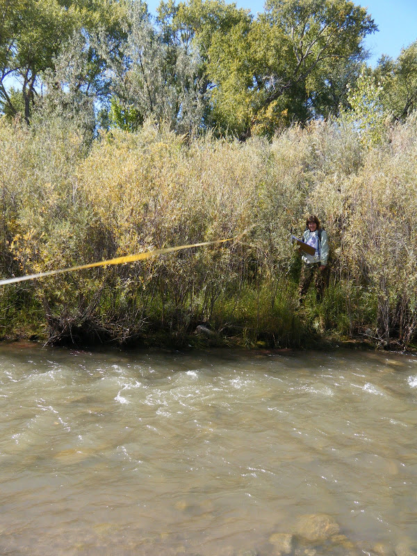
Most plants that cannot tolerate saturated soil conditions for days at a time, like Alders, will not grow below BF, while willows and cottonwood can. Also, the top of point or side bars can indicate the height of BF, but on the Rio Embudo, near Dixon NM, BF indicators were contradictory and hard to find. Is BF just a few centimeters above the base-flow water, or are all the willow below BF?
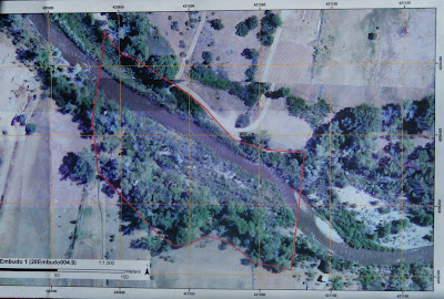
A number of bars and scour features at different heights further compounded the mystery. It was time to seek out other clues. One source of potential indicators was our aerial imagery, which was taken during Spring runoff, 2008:
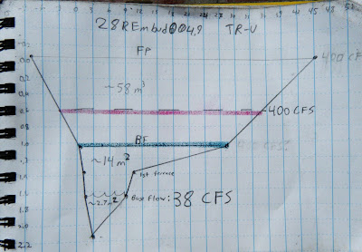
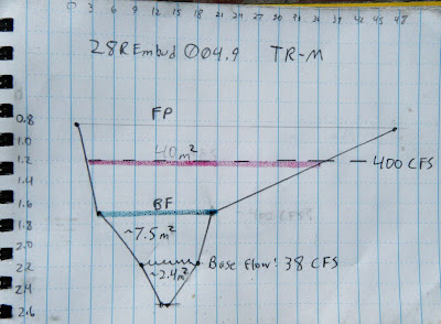
The point bars at bottom right are bisected by a side channel that is several feet above the base level today. That means BF must be at least that high, and would probably inundate most of the willows. Corroborating this, the landowner reports that the willows are indeed flooded almost every year. But exactly how high is BF? To gather more data, we surveyed three channel cross sections, or transects (TR), noting the heights of the major terraces.
TR-Upper
TR-Middle
Tr-Lower
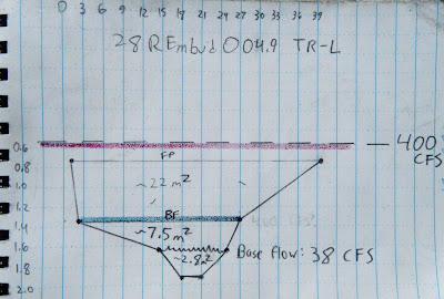
On each of these cross sections we marked where the current base flow water level is, where we think BF is, and where we think Flood Prone (FP) might be. To check these guesses, we correlated those heights with flow data from a USGS gauge just downstream:
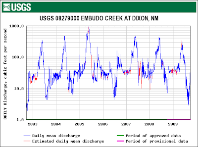
From this graph we could see that the high water level with recurrence every 1 -2 years is about 400 cubic feet per second (CFS). We could also see that the current flow was about 38 CFS. If the Rio Embudo is flowing with 38 CFS today, how high would a BF flow of 400 CFS be?
between the flow today and BF flow. To figure that out we might need to correct for any changes in the velocity (feet/second). Manning's Equation:
 shows that velocity V is proportional to a constant, u, inversely proportional to a coefficient of friction, n, varies to the 2/3 power of channel cross-sectional area, R, and to the 1/2 power of slope, S. Since neither slope nor the constant would change, we can discount them and focus on n and R; n will likely increase because the willows will act like a series of giant combs, increasing friction, and R will also obviously have to increase. For example, doubling the height of the water would multiply that term by 1.6. Unfortunately, coefficients of friction need to be experimentally determined, so we can only guess at n. To make things easier, I decided friction would also increase by a factor of 1.6, to exactly cancel out R. In other words, I don't think the velocity would change by much.
So it is a simple matter of geometry to calculate the cross-sectional area that would correspond to 400 CFS on our cross sections (red lines on the cross-sections, above). Without exception, this height is higher than our field-determined BF (green lines on the cross-sections, above) and, at least for TR-L, even higher than our FP height.
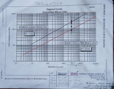
But is this right? Are we getting closer to the truth? To check, we can calibrate our answers for the Rio Embudo against data published by Natural Channel Design on a large number of other Southwestern rivers:
I plotted both our field-determined BF cross-sectional area (green points) and the USGS-determined BF cross-sectional area (red points) on the regional curve above. The green points seem to fall on the line for New Mexico, while the red points fall on the Arizona line, corroborating our field measurements and casting doubt on the USGS. However, the watershed above Dixon is very impermeable and could behave more like AZ than NM. I think the true value is probably somewhere in-between the field and USGS values.
This line is probably as close as any to Bankfull:
Most plants that cannot tolerate saturated soil conditions for days at a time, like Alders, will not grow below BF, while willows and cottonwood can. Also, the top of point or side bars can indicate the height of BF, but on the Rio Embudo, near Dixon NM, BF indicators were contradictory and hard to find. Is BF just a few centimeters above the base-flow water, or are all the willow below BF?
 |
| From Rio Embudo at Dixon, NM Hydrology Analysis |
 |
| From Rio Embudo at Dixon, NM Hydrology Analysis |
TR-Upper
 |
| From Rio Embudo at Dixon, NM Hydrology Analysis |
TR-Middle
 |
| From Rio Embudo at Dixon, NM Hydrology Analysis |
Tr-Lower
 |
| From Rio Embudo at Dixon, NM Hydrology Analysis |
On each of these cross sections we marked where the current base flow water level is, where we think BF is, and where we think Flood Prone (FP) might be. To check these guesses, we correlated those heights with flow data from a USGS gauge just downstream:
 |
| From Rio Embudo at Dixon, NM Hydrology Analysis |
between the flow today and BF flow. To figure that out we might need to correct for any changes in the velocity (feet/second). Manning's Equation:
 shows that velocity V is proportional to a constant, u, inversely proportional to a coefficient of friction, n, varies to the 2/3 power of channel cross-sectional area, R, and to the 1/2 power of slope, S. Since neither slope nor the constant would change, we can discount them and focus on n and R; n will likely increase because the willows will act like a series of giant combs, increasing friction, and R will also obviously have to increase. For example, doubling the height of the water would multiply that term by 1.6. Unfortunately, coefficients of friction need to be experimentally determined, so we can only guess at n. To make things easier, I decided friction would also increase by a factor of 1.6, to exactly cancel out R. In other words, I don't think the velocity would change by much.
So it is a simple matter of geometry to calculate the cross-sectional area that would correspond to 400 CFS on our cross sections (red lines on the cross-sections, above). Without exception, this height is higher than our field-determined BF (green lines on the cross-sections, above) and, at least for TR-L, even higher than our FP height.
But is this right? Are we getting closer to the truth? To check, we can calibrate our answers for the Rio Embudo against data published by Natural Channel Design on a large number of other Southwestern rivers:
 |
| From Rio Embudo at Dixon, NM Hydrology Analysis |
This line is probably as close as any to Bankfull:
|
| From Rio Embudo at Dixon, NM Hydrology Analysis |
Evaluating Restoration Potential at Taos-area Streams
We use a four-tiered scale to rate restoration potential, basically A, B, C, D:
A is fine, possibly excepting some irrigation
B is for "needs beaver!", and/or stop grazing
C needs instream structures and earth moving equipment to restore functionality
D can't be helped
Rio Costillo. Upstream landowner's home is within flood-prone area and would certainly be an impediment to any restoration effort, while downstream landowner's stretch has been dredged. D
Rio Fernando: A thriving beaver population has created extensive wetlands composed of Typha and Salix exigua, but completely extirpated Populus from the reach. A (maybe plant cottonwood)
Santa Barbara Upper: A main channel circumvents the beaver ponds and side channels and appears somewhat channelized, with low habitat diversity (and hence few fish). What is causing the main channel to bypass beaver dams and downcut? A?
Rio Pueblo: Irrigation returns from irrigated pastures along the North; humans have attempted to replace breached beaver dams and drying beaver ponds with rock-and-plastic "fisherman's dams". B
For more site descriptions, click on the links above.
A is fine, possibly excepting some irrigation
B is for "needs beaver!", and/or stop grazing
C needs instream structures and earth moving equipment to restore functionality
D can't be helped
 |
| From Natural Heritage New Mexico - Taos Streams |
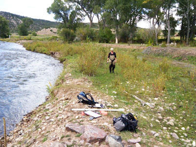
Rio Costillo. Upstream landowner's home is within flood-prone area and would certainly be an impediment to any restoration effort, while downstream landowner's stretch has been dredged. D
 |
| From Natural Heritage New Mexico - Taos Streams |
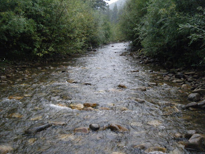
Rio Fernando: A thriving beaver population has created extensive wetlands composed of Typha and Salix exigua, but completely extirpated Populus from the reach. A (maybe plant cottonwood)
 |
| From Natural Heritage New Mexico - Taos Streams |
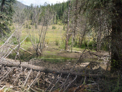
Santa Barbara Upper: A main channel circumvents the beaver ponds and side channels and appears somewhat channelized, with low habitat diversity (and hence few fish). What is causing the main channel to bypass beaver dams and downcut? A?
 |
| From Natural Heritage New Mexico - Taos Streams |
Rio Pueblo: Irrigation returns from irrigated pastures along the North; humans have attempted to replace breached beaver dams and drying beaver ponds with rock-and-plastic "fisherman's dams". B
For more site descriptions, click on the links above.
Wednesday, September 23, 2009
Rio Puerco, NM: BEFORE and AFTER
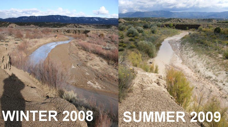
The furthest downstream restoration site is doing well. Note how the roads have revegetated.
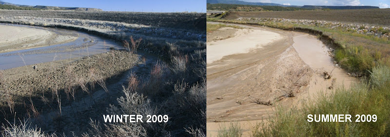
The large berm in the background is the "remeander" dam that was built a couple years ago to push the Puerco back into its original channel. In the foreground an In-Stream Willow Planting (ISWP) immediately after it was planted (left) and then after a single growing/flooding season (right). This planting did not incorporate wattles. It has largely washed out as the river channel continued its lateral migration toward river right. A large amount of new erosion is visible along the right side of the channel, which is exactly what this planting tried to prevent. Unfortunately, it is working against the natural migration of the river.
The same ISWP, looking upstream. The main channel is now flowing (and cutting) right along the bank. The point bar on the left has widened.
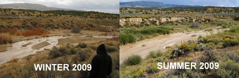
These photos show the Guardian's plantings immediately downstream from the bridge. This old channel is now receiving flow because of the remeander. It is a healthy channel with an active floodplain. All of the cottonwoods and willows received overbank flooding from the summer monsoons, and did very well. Its a real jungle down there!
These photos show an ISWP on Guardian's State Land. It is the middle of three such ISWPs on State Land. The channel through this reach is downcut and straight, almost like a ditch, and the plantings sought to induce meanders. While the plantings didn't wash out, it doesn't look like the willow are doing very well; in this wet year the bottom of the channel may have been too wet for them. Looking further downstream, one can see sedges growing into the channel, forming a natural meander pattern. Planting sedge plugs may be more effective below bankfull.
These photos show the downstream area of the Guardian's State land that was planted in 2008. The ISWP from 2008 is not quite visible under the large cut bank in the center distance. The development and change of the river's channel and associated point bars are visible in the foreground.
For more information and more photos, click on one of the photo links above.
 |
| From Rio Puerco Restoration Evaluation - September 2009 |
The large berm in the background is the "remeander" dam that was built a couple years ago to push the Puerco back into its original channel. In the foreground an In-Stream Willow Planting (ISWP) immediately after it was planted (left) and then after a single growing/flooding season (right). This planting did not incorporate wattles. It has largely washed out as the river channel continued its lateral migration toward river right. A large amount of new erosion is visible along the right side of the channel, which is exactly what this planting tried to prevent. Unfortunately, it is working against the natural migration of the river.
 |
| From Rio Puerco Restoration Evaluation - September 2009 |
The same ISWP, looking upstream. The main channel is now flowing (and cutting) right along the bank. The point bar on the left has widened.
 |
| From Rio Puerco Restoration Evaluation - September 2009 |
These photos show the Guardian's plantings immediately downstream from the bridge. This old channel is now receiving flow because of the remeander. It is a healthy channel with an active floodplain. All of the cottonwoods and willows received overbank flooding from the summer monsoons, and did very well. Its a real jungle down there!
 |
| From Rio Puerco Restoration Evaluation - September 2009 |
These photos show an ISWP on Guardian's State Land. It is the middle of three such ISWPs on State Land. The channel through this reach is downcut and straight, almost like a ditch, and the plantings sought to induce meanders. While the plantings didn't wash out, it doesn't look like the willow are doing very well; in this wet year the bottom of the channel may have been too wet for them. Looking further downstream, one can see sedges growing into the channel, forming a natural meander pattern. Planting sedge plugs may be more effective below bankfull.
 |
| From Rio Puerco Restoration Evaluation - September 2009 |
These photos show the downstream area of the Guardian's State land that was planted in 2008. The ISWP from 2008 is not quite visible under the large cut bank in the center distance. The development and change of the river's channel and associated point bars are visible in the foreground.
 |
| From Rio Puerco Restoration Evaluation - September 2009 |
For more information and more photos, click on one of the photo links above.
Monday, September 21, 2009
Happy Equinox
Today the day and the night are 12 hours each, equal, everywhere in the temperate regions (everywhere that's not the tropics). Since the last, Spring, Equinox, the days have been longer the farther North you are, although they have been longer than the nights everywhere North of the Tropics. But after today farther North places will have shorter and shorter days, while the farther South you go the closer you get to a perfect 12 hour day and 12 hour night. The Equinox also marks the time of the year when the length of days is changing fastest (the second derivative is greatest). This is the time of year when people look up and remark "Fall is coming!".
Monday, September 14, 2009
What are the Laws of Ecology?
PROVISIONAL: (thanks to ecolog subscriber Dr. KC Jensen)
1. There is No Such Thing as a Free Lunch
2. Mother Mature Knows Best
3. Everything Has to Go Somewhere
4. Everything is Connected to Everything Else
1. There is No Such Thing as a Free Lunch
2. Mother Mature Knows Best
3. Everything Has to Go Somewhere
4. Everything is Connected to Everything Else
Sunday, September 06, 2009
New Mexico Heritage Field Work
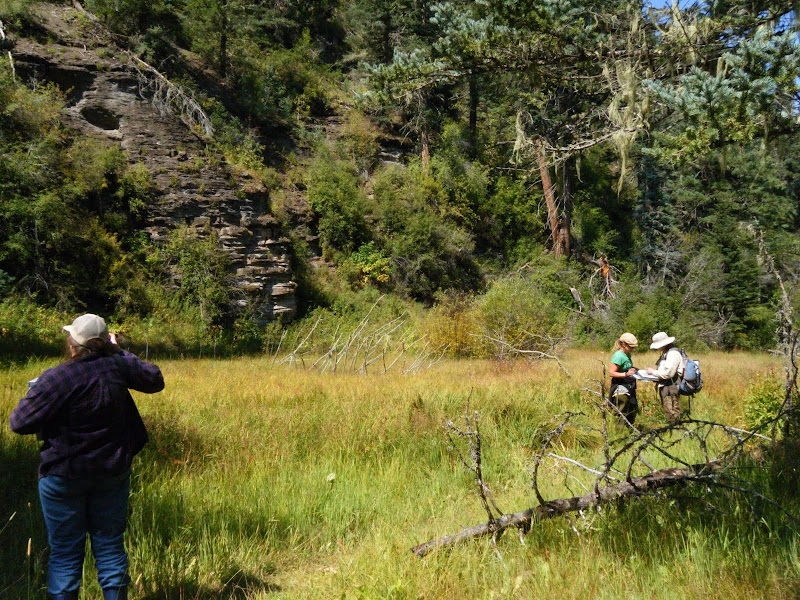 |
| From New Mexico Work |
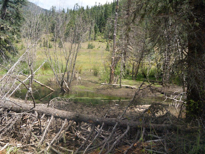
drying up beaverpond
 |
| From New Mexico Work |
 |
| From New Mexico Work |
 |
| From New Mexico Work |
Wednesday, September 02, 2009
Eastern US Trees with Disjunct Populations in the SW's Mountains
Cherries
Hophornbeam (Ostrya)
Mulberry
Dogwood
Acer negundo
Rhus glabra
Soapberry Sapindus
Prunes (Prunus)
Gum Bumelia
Sycamore (Platinus)
Salix nigra....
Ash
Oak?
Hophornbeam (Ostrya)
Mulberry
Dogwood
Acer negundo
Rhus glabra
Soapberry Sapindus
Prunes (Prunus)
Gum Bumelia
Sycamore (Platinus)
Salix nigra....
Ash
Oak?
Tuesday, August 25, 2009
Colorado Natural Heritage Field Work
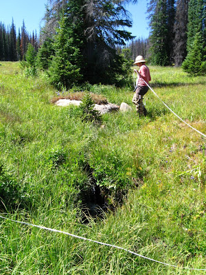
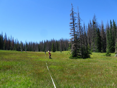
measuring
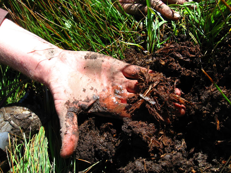
deep buried forest
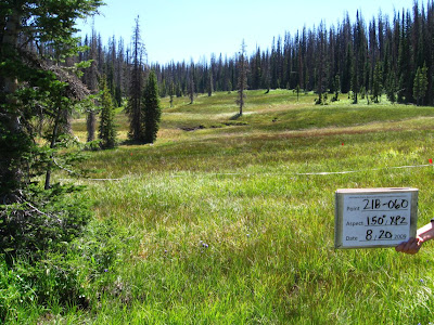
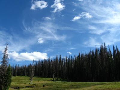
sky
taking notes
human in the landscape
 |
| From New Mexico Work |
 |
| From New Mexico Work |
 |
| From New Mexico Work |
deep buried forest
 |
| From New Mexico Work |
sky
 |
| From New Mexico Work |
taking notes
 |
| From New Mexico Work |
human in the landscape
 |
| From New Mexico Work |
Subscribe to:
Posts (Atom)